> Daily archaeology news from the Internet (on www.archaeologica.org).
> Latest publications : North Africa, Sahara, West Africa - in french
> Latest publications : Central Africa - in french
> African-archaeology.net news archives : 2011 - 2010 - 2008 - 2007 - 2006 -
|
Satellites unearthing ancient Egyptian ruins (Egypt) 23 December 2008 (CNN) -- Archaeologists believe they have unearthed only a small fraction of Egypt's ancient ruins, but they're making new discoveries with help from high-tech allies -- satellites that peer into the past from the distance of space. "Everyone's becoming more aware of this technology and what it can do," said Sarah Parcak, an archaeologist who heads the Laboratory for Global Health at the University of Alabama at Birmingham. "There is so much to learn." Images from space have been around for decades. Yet only in the past decade or so has the resolution of images from commercial satellites sharpened enough to be of much use to archaeologists. Today, scientists can use them to locate ruins -- some no bigger than a small living room -- in some of the most remote and forbidding places on the planet. In this field, Parcak is a pioneer. Her work in Egypt has yielded hundreds of finds in regions of the Middle Egypt and the eastern Nile River Delta. Parcak conducted surveys and expeditions in the eastern Nile Delta and Middle Egypt in 2003 and 2004 that confirmed 132 sites that were initially suggested by satellite images. Eighty-three of those sites had never been visited or recorded. In the past two years, she has found hundreds more, she said, leading her to amend an earlier conclusion that Egyptologists have found only the tip of the iceberg. "My estimate of 1/100th of 1 percent of all sites found is on the high side," Parcak said. These discoveries are of no small significance to the Egyptian government, which has devoted itself anew to protecting archaeological sites from plunder and encroachment. The Supreme Council of Antiquities has restricted excavation in the most sensitive areas along the Nile -- from the Great Pyramids at Giza on the outskirts of Cairo to the carvings of Ramses II in the remote south. Antiquities officials hope the move will encourage more surveys in the eastern Nile Delta in northern Egypt, Parcak said, where encroaching development in the burgeoning nation of 82 million poses the greatest threat to the sites. Old and modern methods Parcak's process weds modern tools with old-fashioned grunt work. The archaeologist studies satellite images stored on a NASA database and plugs in global positioning coordinates for suspected sites, then tramps out to see them. Telltale signs such as raised elevations and pot shards can confirm the images. As a result, the big picture comes into view. "We can see patterns in settlements that correspond to the [historical] texts," Parcak said, "such as if foreign invasions affected the occupation of ancient sites. "We can see where the Romans built over what the Egyptians had built, and where the Coptic Christians built over what the Romans had built. "It's an incredible continuity of occupation and reuse." The flooding and meanders of the Nile over the millennia dictated where and how ancient Egyptians lived, and the profusion of new data has built a more precise picture of how that worked. "Surveys give us information about broader ancient settlement patterns, such as patterns of city growth and collapse over time, that excavations do not," said Parcak, author of a forthcoming book titled "Satellite Remote Sensing and Archaeology." The vagaries of climate in the region make satellite technology advantageous, too. "Certain plants that may indicate sites grow during certain times of the year," Parcak said, "while sites may only appear during a wet or dry season. This is different everywhere in the world." Archaeologists working in much more verdant climates, such as Cambodia and Guatemala, also have used the technology to divine locations of undiscovered ruins. They have been able to see similarities between the vegetation at known sites and suspected sites that showed up in fine infrared and ultraviolet images covering wide areas of forbidding terrain. "For the work I do [in Egypt], I need wet season images as wet soil does a better job at detecting sites with the satellite imagery data I use," Parcak said. "I can pick the exact months I need with the NASA satellite datasets." Benefits of a bird's-eye view Remote subsurface sensing has been used in archaeology in one form or another for years, though the term "remote" doesn't necessarily imply great distance. Typically, a surveyor has wheeled a sensing device over a marked-out area to determine what lies below. The sensing devices employ any of an array of technologies, such as Ground Penetrating Radar. They bounce signals off objects below the surface and translate the data into images that a scientist's trained eye can decipher. Multispectral imaging encompasses technologies that "see" what the human eye can't, such as infrared and ultraviolet radiation. Scientists have used it for years to study the Earth's surface for a variety of purposes. Until resolution of these images improved, though, the only way to produce a sharp image was to be relatively close to the ground. For those lugging unwieldy gear across jungle and desert, an effective bird's-eye view can change the world. It lets them leave behind the days and days of meticulous "prospecting" and get results from airplane-mounted sensors or, later on, a flyover by an advanced satellite. One of the most advanced is called QuickBird, which has been in orbit since 2001 and can provide high-resolution images of 11-mile-wide swaths. The satellite can collect nearly 29 million square miles of imagery data in a year, according to DigitalGlobe, which developed and operates QuickBird. The company, based in Longmont, Colorado, is working on an upgrade. WorldView-2, to be launched in 2009, will offer sharper resolution of visual and multispectral images than QuickBird, according to the company's Web site. In the end, though, a tool is only as useful as its wielder. "Most of the advances have come through processing on the ground by end users such as Dr. Parcak," said DigitalGlobe spokesman Chuck Herring. Source : http://www.cnn.com/2008/TECH/science/12/23/satellites.archaeology.egypt/
| |
|
Pair of tombs discovered in Egypt (Egypt) 23 December 2008 Egyptian archaeologists say they have discovered a pair of 4,300-year-old tombs that indicate a burial site south of Cairo is bigger than expected. The tombs at the Saqqara necropolis belong to two officials from the court of the Pharaoh Unas, Egypt's antiquities chief said. One was for the official in charge of quarries used for building pyramids, the other for the head of music. Hieroglyphics decorate the entrances of both the newly discovered tombs. Zahi Hawass, Egypt's top archaeologist, told reporters that the tombs represented a "major" find. "The discovery of the two tombs are the beginning of a big, large cemetery," he said. New discoveries are frequently made at Saqqara, including the unearthing of the remains of a pyramid in November. Mr Hawass said 70% of Egypt's ancient monuments remain buried. "We are continuing our excavation and we are going to uncover more tombs in the area to explain the period of dynasty five and dynasty six," he added, referring to a period more than 4,000 years ago. The contents of the newly found tombs have long since been stolen, Mr Hawass said. The entrance of the tomb of the official in charge of music, Thanah, shows carved images of her smelling lotus flowers. The other official whose tomb was discovered, Iya Maat, oversaw the extraction of granite and limestone from Aswan and other materials from the Western Desert for the construction of nearby pyramids. Source : http://news.bbc.co.uk/2/hi/middle_east/7796675.stm
| |
|
Ancient African Exodus Mostly Involved Men, Geneticists Find (Africa) 19 December 2008 Modern humans left Africa over 60,000 years ago in a migration that many believe was responsible for nearly all of the human population that exist outside Africa today. Now, researchers have revealed that men and women weren’t equal partners in that exodus. By tracing variations in the X chromosome and in the non-sex chromosomes, the researchers found evidence that men probably outnumbered women in that migration. The scientists expect that their method of comparing X chromosomes with the other non-gender specific chromosomes will be a powerful tool for future historical and anthropological studies, since it can illuminate differences in female and male populations that were inaccessible to previous methods. While the researchers cannot say for sure why more men than women participated in the dispersion from Africa—or how natural selection might also contribute to these genetic patterns—the study’s lead author, Alon Keinan, notes that these findings are “in line with what anthropologists have taught us about hunter-gatherer populations, in which short distance migration is primarily by women and long distance migration primarily by men.” These findings are published in Nature Genetics. Source : http://www.newswise.com/articles/view/547619/?sc=rssn
| |
|
Sudan statue find gives clues to ancient language (Sudan) 16 December 2008 KHARTOUM, Dec 16 (Reuters) - Archaeologists said on Tuesday they had discovered three ancient statues in Sudan with inscriptions that could bring them closer to deciphering one of Africa's oldest languages. The stone rams, representing the god Amun, were carved during the Meroe empire, a period of kingly rule that lasted from about 300 BC to AD 450 and left hundreds of remains along the River Nile north of Khartoum. Vincent Rondot, director of the dig carried out by the French Section of Sudan's Directorate of Antiquities, said each statue displayed an inscription written in Meroitic script, the oldest written language in sub-Saharan Africa. "It is one of the last antique languages that we still don't understand ... we can read it. We have no problem pronouncing the letters. But we can't understand it, apart from a few long words and the names of people," he told reporters in Khartoum. Sudan has more pyramids than neighbouring Egypt, but few people visit its remote sites, and repeated internal conflicts have made excavation difficult. Rondot said the dig at el-Hassa, the site of a Meroitic town, had uncovered the first complete version of a royal dedication, previously found only on fragments of carvings from the same period. He said experts were still trying to work out the meaning of the words by comparing them with broken remnants of similar royal dedications in the same script. "It's an important discovery ... quite an achievement," Rondot said. The statues were found three weeks ago under a sand dune at the site of a temple to the god Amun, an all-powerful deity represented by the ram in Sudan. The site is close to Sudan's Meroe pyramids, a cluster of more than 50 granite tombs 200 kms (120 miles) north of the capital that are one of the main attractions for Sudan's few tourists. Rondot said the dig, funded by the French foreign ministry, would also provide vital information on the reign of a little-known king, Amanakhareqerem, mentioned in the inscriptions on the rams. "Before we started the dig we only had four documents in his name ... We don't even know where he was buried," he said. "We are beginning to understand the importance of that king." (Editing by Katie Nguyen and Tim Pearce) Source : http://africa.reuters.com/wire/news/usnLG432974.html
| |
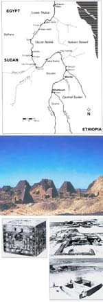 |
From brief limelight to obscurity (Sudan) 3 December 2008 It's full speed ahead for the Sudanese hydroelectric project which will flood the ancient kingdom of Meroe, says Jill Kamil Technology and archaeology are at odds again. The Meroe High Dam, otherwise known as the Multi-Purpose Hydro Project or Hamdab Dam, is well underway -- and the archaeological remains of the ancient African kingdom of Meroe which developed along the upper reaches of the Nile is destined to oblivion. The purpose of the dam being constructed close to the Fourth Cataract, about 200 kilometres north of Khartoum, is to generate electricity. It is the largest hydropower project currently under construction in Africa. With a length of some nine kilometres, and a crest height of up to 67 kilometres it is reminiscent of the High Dam at Aswan constructed in the 1960s. It too is designed with a concrete-faced rock-fill barrage on each river bank, the left river channel with a clay core, and the right with a live water section. Once completed, its 200-kilometre long reservoir, with a capacity to produce 1,250 megawatts of power, will displace 50,000 people and inundate countless archaeological sites including Meroe in the African kingdom of Kush, sub-Saharan Africa's earliest urban civilisation. Meroe, which is situated at a strategic location in the region known as Butana, enjoyed stability when Kushites moved the centre of their government there from the old capital of Napata (Nuri) -- which gradually declined but nevertheless retained its sacred status. The new capital grew and flourished contemporaneously with the Persian rule of Egypt, the later Egyptian dynasties, and the Ptolemaic and Roman periods, which is to say for nine centuries. The Meroitic Kingdom controlled trade routes -- east to the Red Sea, west to Kordofan and Darfur, north to Egypt, and south to central Africa -- and its sphere of influence spread even as far north as the island of Philae within sight of Aswan. Traders found markets for their ivory, gold, ebony and live animals, and the names of its kings have been documented by historians, even down to the approximate lengths of their reigns. The first century AD marked the peak of Meroitic ascendancy, and its flourishing economy is reflected in the advanced culture seen in the superior quality of Meroitic crafts, particularly fine work in jewellery and pottery. Then started a slow decline, precipitated first by the inroads of two desert peoples, the Blemmyes and the Noba; then in competition with the new kingdom of Axum in northern Ethiopia when it emerged as the largest commercial centre in north-east Africa; and finally, in about 350 AD, when the first Christian king of Axum led a campaign into the region and defeated Meroitic troops near the confluence of the White Nile and the Atbara. By the beginning of the fourth century Meroe was no more. It fell to ruin and became a part of legendary history. Meroe was not included among the sites studied and protected when the High Dam at Aswan was built in the 1960s and Nubia was subjected to the largest archaeological salvage operation ever known, because it did not fall within the threatened area. Now the area is threatened by the Meroe High Dam Project which was signed in 2002 and 2003. Despite numerous efforts to curb the construction of dams along the Upper Nile by the board of the Nubian Society (which represents a body of the international archaeological community working closely with the National Corporation for Antiquities and Museums), and contact with major stakeholders in Sudan to give due consideration to potential damage to a major heritage sites, the project has moved ahead. Chinese, German and French contractors began work on river diversion and construction of the concrete dams early in 2004. The reservoir impounding started in mid-2006, and the land for the reservoir was marked out. The local population nearest the construction site were moved, without prior warning, to a new location. Flooding started in August 2007. By the end of this year large segments of the land will be underwater, and when the level in the reservoir reaches 300 metres all ten generating units will be operational. This is scheduled before the end of 2008 or the beginning of 2009. Time is running out and archaeologists are watching closely to see what they can rescue before it is too late. In his paper at the Eleventh Conference for Nubian Studies in Warsaw, Derek Welsby of the British Museum, president of the International Association of Nubian Studies, said that in the past the assumption that this section of the Upper Nile was an inhospitable region led archaeologists to consider it a marginal zone avoided by the major cultures which flourished in the Nile Valley to the north and south. "The current work," he said, "is causing a radical rethinking of this position. Vast numbers of archaeological sites are now known". He outlined the work of the many archaeological missions active in the Fourth Cataract region, and summarised their achievements in casting light on the Paleolithic occupation, through the Neolithic, Kerma and Kushite periods, to the post-Meroitic, Mediaeval and post-Medieval remains. "The region may be rocky and inhospitable, but archaeologists now know that it was not a marginal zone avoided by the major cultures," he said. In fact the Fourth Cataract region is rich in archaeology, and it is unfortunate that, unlike the UNESCO project of the 1960s when the High Dam was built at Aswan, Sudanese Nubia has no monuments of the calibre of Abu Simbel to attract world attention to what is being done. The half-dozen Sudanese and foreign missions working in the threatened area have already pin-pointed hundreds of settlements and cemeteries spanning four millennia, and lithic artefacts, rock art, pottery, and even a granite pyramid -- the only one so far known in Sudan -- have been found, not to mention mediaeval Christian remains and Islamic cemeteries. The idea of a Nile dam at the Fourth Cataract is not new. During the first half of the 20th century, the authorities of the Anglo-Egyptian Sudan proposed it several times with a view to creating conditions for cotton-growing and providing flood protection for the lower Nile Valley. After Sudan gained independence in 1956, the idea of a dam in Sudan was abandoned in favour of the High Dam at Aswan. In 1979, under the government of President Nimeiri, the plan was revived with a view to producing hydro-electricity to meet Sudan's rising demand. Feasibility studies were carried out, but the project stalled for insufficient funding and lack of investor interest. The situation changed when the country started exporting oil in commercial quantities in the years 1999/2000, when improved credit-worthiness brought an influx of foreign investment and contracts for the construction of the Meroe Dam Project. While the inevitable loss of sites beneath the Meroe Dam lake is to be regreted, the project has provided the stimulus for archaeological research and that is a good thing. Thanks to the wealth of data resulting from various surveys, particularly for the Meroitic and later periods, attention has been drawn to what was hitherto a neglected area and field of investigation. Unexpectedly, evidence has come to light of formally and legally stratified society in Meroitic Nubia, with royalty at the top of the scale and slaves at the bottom. The high status of women within the royal families is now well attested both for Kush and for Christian Nubia. And as for slaves in Islamic times, while a number were exported, most of them appear to have lived in the households of the owners and, because of their attachment to families, were given humane consideration at the time of death and buried with the same ritual considerations as free men. Meroe is already attracting tourists. Indeed, it is somewhat reminiscent of the last days of Egyptian Nubia before the completion of the High Dam at Aswan. The area is within easy reach of Khartoum, only a couple of hours away by car, and visitors are coming to see contractors at work on the reservoir and visit those sites that lie above the expected high waterline of the lake. In fact, even as this article goes to press, I hear that tourist infrastructure is being provided in some areas, that a pipeline is bringing fresh water to the site, and that a small visitor's centre is being built to provide the necessary facilities. Source : http://weekly.ahram.org.eg/2008/925/heritage.htm
|
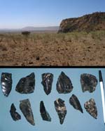 Stone tools found at the archaeological site of Gademotta, in the Ethiopian Rift Valley, were likely crafted by the earliest Homo sapiens, according to a study published in December 2008. Stone tools found at the archaeological site of Gademotta, in the Ethiopian Rift Valley, were likely crafted by the earliest Homo sapiens, according to a study published in December 2008.The tools were uncovered in the 1970s, but it was not until this year that new dating techniques revealed the tools to be far older than the oldest known Homo sapien bones, which are around 195,000 years old. |
Humans 80,000 Years Older Than Previously Thought ? (Ethiopia) 3 December 2008 Modern humans may have evolved more than 80,000 years earlier than previously thought, according to a new study of sophisticated stone tools found in Ethiopia. The tools were uncovered in the 1970s at the archaeological site of Gademotta, in the Ethiopian Rift Valley. But it was not until this year that new dating techniques revealed the tools to be far older than the oldest known Homo sapien bones, which are around 195,000 years old. Using argon-argon dating—a technique that compares different isotopes of the element argon—researchers determined that the volcanic ash layers entombing the tools at Gademotta date back at least 276,000 years. Many of the tools found are small blades, made using a technique that is thought to require complex cognitive abilities and nimble fingers, according to study co-author and Berkeley Geochronology Center director Paul Renne. Some archaeologists believe that these tools and similar ones found elsewhere are associated with the emergence of the modern human species, Homo sapiens. "It seems that we were technologically more advanced at an earlier time that we had previously thought," said study co-author Leah Morgan, from the University of California, Berkeley. The findings are published in the December issue of the journal Geology. Complicated family tree The lack of bones at Gademotta makes it difficult to determine exactly who made these specialist tools and whether this really pushes the date of the beginning of modern humans, or Homo sapiens, back 80,000. Some archaeologists believe it had to be Homo sapiens while other experts think that our earlier ancestors may have had the required mental capability and manual dexterity. Regardless of who made the tools, the dates help to fill a key gap in the archaeological record, according to some experts. "The new dates from Gademotta help us to understand the timing of an important behavioral change in human evolution," said Christian Tryon, a professor of anthropology from New York University, who wasn't involved in the study. If anything, the story has now become more complex, added Laura Basell, an archaeologist at the University of Oxford in the U.K. "The new date for Gademotta changes how we think about human evolution, because it shows how much more complicated the situation is than we previously thought," Basell said. "It is not possible to simply associate specific species with particular technologies and plot them in a line from archaic to modern." Desirable Location Gademotta was an attractive place for people to settle, due to its close proximity to fresh water in Lake Ziway and access to a source of hard, black volcanic glass, known as obsidian. "Due to its lack of crystalline structure, obsidian glass is one of the best raw materials to use for making tools," Morgan explained. In many parts of the world, archaeologists see a leap around 300,000 years ago in Stone Age technology from the large and crude hand-axes and picks of the so-called Acheulean period to the more delicate and diverse points and blades of the Middle Stone Age. At other sites in Ethiopia, such as Herto in the Afar region northeast of Gademotta, the transition does not occur until much later, around 160,000 years ago, according to argon dating. This variety in dates supports the idea of a gradual transition in technology. "A modern analogy might be the transition from ox-carts to automobiles, which is virtually complete in North America and northern Europe, but is still underway in the developing world," said study co-author Renne, who received funding for the Gadmotta analysis from the National Geographic Society's Committee for Research and Exploration. (The National Geographic Society owns National Geographic News.) Morgan, of UC Berkeley, speculates that the readily available obsidian at Gademotta may explain why the technological revolution occurred so early there. Source : http://news.nationalgeographic.com/news/2008/12/081203-homo-sapien-missions.html
|
|
The Long Road to Modernity - Middle Stone Age (Ethiopia) 1 December 2008 Most experts agree that Homo sapiens arose in Africa about 200,000 years ago and had more brainpower than earlier hominid species. But it's a matter of debate whether modern humans got smarter in one big cognitive leap or gradually developed their greater intelligence. New dating of an important hominid site in Ethiopia suggests that the road to advanced cognition was long and winding. Anthropologists and archaeologists rely on stone tools and other artifacts to gauge the sophistication of ancient humans. About 1.7 million years ago in Africa, Homo erectus, an ancestor of modern humans, started using large hand axes and cleavers. This know-how spread to Asia and Europe and remained cutting-edge technology for well over a million years. Eventually, however, it gave way to the Middle Stone Age, which featured smaller and more sophisticated blades and spearheads. Many researchers have assumed that these weapons and tools were made by modern humans, because nearly all of them have been found at sites dated later than 195,000 years ago, the age of the oldest known H. sapiens fossils. That would imply a big cognitive leap on the part of modern humans, as they would have essentially developed a complex technology as soon as they arrived on the scene. But not all evidence jibes with this theory. In the 1990s, for example, archaeologists dated a Middle Stone Age site in Ethiopia called Gademotta to 235,000 years ago--implying that the technology had been maturing for a while before the arrival of modern humans--although the accuracy of that dating has been questioned. A second site, Kapthurin in Kenya, was more reliably dated in 2002 to 285,000 years ago, but researchers have been very reluctant to accept just one site as evidence that the Middle Stone Age started so early. Both sites are in Africa's volcanic Rift Valley, the birthplace of many hominid species. Now two geochronologists from the University of California, Berkeley, Leah Morgan and Paul Renne, have redated Gademotta using the argon-argon method, an improved technique for dating volcanic rock that is considered more accurate than the potassium-argon method previously employed at the site. The new results, reported in this month's issue of Geology, push the artifacts at Gademotta back to at least 280,000 years ago, essentially the same age as those at Kapthurin. Morgan and Renne suggest that the early dates at both Gademotta and Kapthurin indicate that the tools were probably not invented by modern humans but rather by ancestral hominids intermediate between H. erectus and H. sapiens. A few fossils that might represent such ancestors have been found in Africa over the past decades and are thought to be between 400,000 and 200,000 years old. Sally McBrearty, an anthropologist at the University of Connecticut, Storrs, and a leader of the excavations at Kapthurin, says that the new Gademotta dates provide "solid confirmation" of the early appearance of Middle Stone Age technology. And Christian Tryon, an anthropologist at New York University, says that the "major behavioral changes" represented by the early invention of these sophisticated tools may have even helped stimulate the advances in cognition that would become the hallmark of modern humans. Source : http://sciencenow.sciencemag.org/cgi/content/full/2008/1201/1
| |
|
Clues to why modern humans migrated... (South Africa) 21 November 2008 In a cave 70 000 years ago, something strange was beginning to happen. The occupants, who once lived in the cave, were behaving differently from their forefathers. They were producing some of the first examples of jewellery and developing new technologies that were to give them an edge in years to come. It wasn't an isolated event, across the African continent, the same thing was happening among bands of hunter gatherers from the Western Cape to Morocco. What sparked this, no one knows. It was so dramatic that some believe it might originally have been caused by a sudden change in the structure of our ancestor's brains. That cave is Sibudu Cave, situated near Tongaat, in KwaZulu Natal, and it is here that an international team of scientists are unearthing the clues to this event and are trying to make sense of it all. Their findings were published as part of a larger southern African dating project, in the journal Science at the end of October. What they found in the cave were minute seashells that were likely strung together to make a necklace, bone arrowheads and the residues of what is possibly the earliest example of glue. Also present were finely-crafted stone tools never seen before in earlier deposits. These tools were probably parts of spearheads. To archaeology professor Lyn Wadley of Wits University this haul reveals the earliest workings of what she calls complex cognitive behaviour. In these artefacts, dug from the bottom of the cave are the signs of some of humans' earliest known attempts at making jewellery. "We now know that these beads are 70 000 years old. "Similarly-aged perforated seashells were discovered in Blombos Cave, Western Cape," Wadley explained, from Sibubu where she is continuing with her dig. These changes happened in the space of about 5 000 years, an extraordinary short period of time, in the span of evolution. Wadley is part of a team that includes Dr Zenobia Jacobs and Professor Richard "Bert" Roberts from the University of Wollongong, Australia. For these Australian scientists, what has come out of Sibubu cave could help explain what motivated the first modern humans to migrate out of Africa, about 80 000 years ago, and later island hop from Asia to Australia. New technological know how gave the migrating humans an advantage. "With the perforated seashells we see people demonstrating that they are part of a group, or a particular status within that group. "The use of personal ornamentation is evidence of symbolic behaviour even today," said Wadley. The team has also found traces of red ochre which could have been used to paint ornaments. Helping the team in their research was some high-tech gadgetry that aided them in piecing together how those cave dwellers lived all those years ago. With the help of a microscope the academics found traces of residue on some of the stone tools. It turned out to be plant gum mixed with red ochre, and was probably glue. "Making such glue and using it to attach a spearhead to a shaft requires complex cognitive abilities because it involves holding many things in mind during the process," Wadley said. Earlier this year Dr Lucinda Backwell of the Bernard Price Institute for Palaeontological Research revealed that Sibubu Cave had produced what was believed to be the first bone arrow head, aged between 65 000 and 62 000 years. The arrowheads may have been used for hunting blue duiker and plains game, then found close to the cave. Again Wadley stressed that making such arrowheads and figuring out the technology that goes with manufacturing bows would have required a leap in thinking. The team was even able to ascertain through studying burnt charcoal what these early humans were using for firewood. In the ancient ash were found charred bones, many of them smashed so as to get at the nutritious marrow inside. A microscopic study of the sediments in the cave revealed seeds that suggested that bundles of reeds were used as early mattresses. It wasn't just at Sibubu that early humans were showing the innovation that today we take for granted. Similar artefacts have been found in Morocco and at other archaeological sites in South Africa and Wadley believes these developments occurred independently of each other. As to what triggered this change in early human behaviour, Wadley suggests that it might be up to academics in other scientific fields to answer that question. "It might have been some sort of genetic mutation that made early people able to think in a modern way, but this suggestion needs to be followed up by someone other than an archaeologist," she said. Source : http://www.int.iol.co.za/index.php?set_id=1&click_id=588&art_id=vn20081121054843530C280787
| |
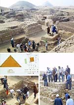 |
New pyramid found at Saqqara (Egypt) 20 November 2008 The newly discovered subsidiary pyramid of queen Sesheshet, mother of King Teti I, the founder of the Sixth Dynasty, is another clue to understand more such an enigmatic dynasty as Nevine El-Aref writes Last week the announcement of the discovery at the Saqqara necropolis of the 4,300-year-old subsidiary pyramid of Queen Sesheshet, mother of King Teti I, the founder of the Sixth Dynasty, caught the headlines. Not only does it bring the number of pyramids discovered in Egypt to 118, but it enriches our knowledge of the Sixth Dynasty and its royal family members. Sesheshet's pyramid, found seven metres beneath the sands of the Saqqara necropolis, is five metres in height, although originally it reached about 14 metres. The base is square and the sides of the pyramid slope at an angle of 51 degrees. The entire monument was originally cased in fine white limestone from Tura, of which some remnants were also unearthed. Ushabti (model servant) figurines dating from the third Intermediate Period were also found in the area, along with a New Kingdom chapel decorated with a scene of offerings being made to Osiris. Also found were a group of Late Period coffins, a wooden statue of the god Anubis, amulets, and a symbolic vessel in the shape of a cartouche containing the remains of a green substance. These objects will be transported to the Egyptian Museum in Tahrir Square where they will be restored and put on display. According to Zahi Hawass, secretary-general of the Supreme Council of Antiquities (SCA), who led the excavation team, the finds show that the entire area of the Old Kingdom cemetery of Teti was reused from the New Kingdom through to the Roman Period. Culture Minister Farouk Hosni described it as "a great discovery" and said he wished that within the next couple of weeks excavators could find more of the funerary complex of the queen. "Sesheshet's pyramid is the third subsidiary pyramid to be discovered within Teti's cemetery," Hawass said. He added that earlier excavations at the site had revealed the pyramid of King Teti's two wives, Khuit and Iput. "This might be the most complete subsidiary pyramid ever found at Saqqara," he said. Scholars have long believed that Khuit was Teti's secondary wife, but excavations and studies proved that her pyramid was built before that of Queen Iput, who was previously believed to have been Teti's chief queen. The fact that her pyramid was built before Iput's, however, tells us that Khuit was in fact the primary royal wife. Previous excavations at this site have also revealed the funerary temple of Queen Khuit, offering much new information about the decorative codes of queens' monuments of the period. "No one can ever know what's hidden beneath the sands of Egypt," Hawass told Al-Ahram Weekly, adding that the excavators had been somewhat surprised to find a pyramid within Teti's cemetery since they thought the area had been thoroughly explored. In fact, he continued, over the last century, since French archaeologists Auguste Mariette found Teti's pyramid, archaeologists had used the area as a sand dump as they considered it empty and without anything of interest. Teti's pyramid is mostly a pile of rubble constantly threatened with being covered by sand. There is a steep pathway that leads to the burial chamber, where the walls are decorated with the pyramid texts and the ceiling decorated with stars. Inside the chamber was found an undecorated sarcophagus containing a mummified arm and a shoulder, presumably Teti's. Up to now no other parts of Teti's pyramid complex; the valley temple and causeway have been discovered. However, in addition to the subsidiary pyramids of the king's wives and mother, tombs of his consorts and viziers have been found. Among these are those of his chancellors Mereruka and Kagemni. The archaeologists found that a shaft had been created in Sesheshet's pyramid to allow access to her burial chamber, so they do not expect to find Sesheshet's mummy when they reach the burial chamber within the coming two weeks. However, they anticipate finding inscriptions about the queen, whose name, according to Hawass, was only known from being mentioned in a medical papyrus containing a recipe, supposedly created to her request, to strengthen the hair. It is also believed that Queen Sesheshet was instrumental in enabling her son to gain the throne and reconciling two warring factions of the royal family. The dynasty that arose with her son is considered part of the Old Kingdom portion of the history of Egypt, a term designated by modern historians. There was no break in the royal lines or the location of the capital from its predecessors, but significant cultural advances occurred to prompt the designation of different periods by scholars. Until the recent rediscovery of her pyramid, little contemporary evidence about her had been found. Her estates under the title King's Mother are mentioned in the tomb of the early Sixth-Dynasty vizier Mehu, and she is referenced in passing as the mother of King Teti in the remedy for baldness in the Ebers Papyrus. After the death of Unas, the last king of the Fifth Dynasty, Teti took the throne. The exact length of his reign is not known as it was destroyed in the Turin Kings' List, but the last year that can be attributed to his reign was the year of the sixth cattle count, which means roughly 11 years. Many of the officials and administrators from the reign of Unas remained during the rule of Teti, who seemed intent on restabilising the central government. So far nothing is shown about his military campaigns or trade agreements, but it is assumed that diplomatic relations between north and south continued in the customary way. He quarried in the south and imported timber for building from Syria. Teti granted land to Abydos by decree, and he was also the first known king with links to the cult of the goddess Hathor in Dendereh. Reliefs found at Abydos show that he exempted the area from taxes, probably because of a bad harvest or inundation. During Teti's reign high officials were beginning to build funerary monuments that rivalled that of the king. For example, his chancellor Mereruka built a large mastaba consisting of 32 rooms, all richly carved. This is considered a sign that wealth was being transferred from the central court to the officials, a slow process that culminated in the end to the Old Kingdom. Teti may have been murdered by the usurper Userkare; the historian Manetho states that he was murdered by his palace bodyguards in a harem plot. Source : http://weekly.ahram.org.eg/2008/923/he1.htm
|
|
Long-isolated Libya plans new archaeology drive (Lybia) 18 November 2008 TRIPOLI (Reuters) - Libya plans to invite the world's top archaeologists to unearth its ancient past as it tries to lure more tourists after decades in isolation, the head of the government's archaeology department said. With a central role in early human migration, the desert country on the Mediterranean is home to a multitude of ancient and prehistoric sites. Many are thought to remain undiscovered. But years of western sanctions tarnished Libya's image and only a few hundred thousand people visit the north African country each year, compared to over 8 million for neighbouring Egypt. "We will open our arms to the best scientists from Japan to the United States. We will not exclude one major institution, be it Oxford, Cambridge, the Sorbonne or Rome," said Giuma Anag, chairman of the government's archaeology department. In a recent interview, he described discoveries to date as only the tip of the iceberg. The archaeology campaign is backed by leader Muammar Gaddafi's most prominent son, Saif al-Islam, who recently approved setting up of a society for safeguarding archaeology that would coordinate the work of foreign and local researchers. "It is a huge acceleration," Anag told Reuters. "We never had this kind of support before." Archaeology took a back seat after Gaddafi's 1969 Islamic Socialist revolution although work never entirely stopped. Some foreign archaeologists continued work -- making significant finds -- even during the low point of relations with the West. Libya, three times the size of France, was inhabited by humans over 60,000 years ago when Homo Sapiens began moving north from east Africa before colonizing Europe. In ancient times, coastal settlements were established by great civilisations from the Phonecians to the Romans, Greeks, Carthaginians and Ottomans. Archaeological work began in earnest in the 1930s when Italian fascist colonialists hoped to demonstrate the Roman presence and prove Italy's historical dominance of the Mediterranean. That work also led to the discovery of oil. 150,000 YEARS With a low population and dry climate, Libya's secrets are well preserved. Historians say the vast desert was once savannah that supported small communities of which little is known. "We are discovering more about one of the most interesting aspects of human pre-history -- when and how Homo Sapiens left Africa," said Elena Garcea of Cassino University in Italy. With new technology for dating objects, her team has found evidence of human habitation in Libya up to 150,000 years ago and is unearthing details of little-known Early-Middle Stone Age societies. Key discoveries were made in recent years by French researcher Andre Laronde at the ancient Greek port of Apollonia in Cyrenaica, birthplace of the philosopher and mathematician Erastosthenes. In the south, an Italian team has studied rock art to shed light on prehistoric hunter-gatherer communities. A Sicilian group is working on the wreck of a 17th century Venetian warship, the Tigre, scuppered by its captain after a storm drove it south and the Libyan Karamanli fleet gave chase. The team's head, Sebastiano Tusa, says the ship is yielding useful information on the period when Venice's power waned and Turkish forces threatened its eastern Mediterranean possessions. But Tusa's dream is to find a land settlement on the Libyan coast that proves there was a sea route via North Africa for ships travelling between the Western and Eastern Mediterranean in the second millennium B.C. "I'm sure there will be something proving a connection between Crete and the Aegean and Cyrenaica," he said. Libya's government says that as more sites are opened up, it wants to avoid the mass tourism of Egypt and Tunisia and its emphasis on history will help draw a smaller number of discerning travellers. "We will discourage mass tourism which would ... be a disgrace towards this fantastically rich and diverse cultural heritage," said Anag. Source : http://africa.reuters.com/top/news/usnJOE4AH0GQ.html
| |
|
Ancient Egypt had powerful Sudan rival, British Museum dig shows (Sudan) 16 October 2008 New evidence about the power of a Sudanese civilisation that once dominated ancient Egypt has come to light thanks to a British Museum expedition. The Second Kushite Kingdom controlled the whole Nile valley from Khartoum to the Mediterranean from 720BC to 660BC. Now archaeologists have discovered that a region of northern Sudan once considered a forgotten backwater once actually "a real power-base". They discovered a ruined pyramid containing fine gold jewellery dating from about 700BC on a remote un-navigable 100-mile stretch of the Nile known as the Fourth Cataract, plus pottery from as far away as Turkey. Other finds included numerous examples of ancient rock art and 'musical' rocks that were tapped to create a melodic sound. They only made the discoveries after being invited by the Sudanese authorities to help excavate part of the Merowe region, which is soon to be flooded by a large hydro-electric dam. More than 10,000 sites were found. Historians had written off the area as being of little archaeological interest. Dr Derek Welsby, of the British Museum, said: "We had no idea how rich the area was." Remarkably well-preserved bodies, naturally mummified in the desert air, and a cow buried complete with eye ointment were also unearthed. Dr Welsby said the finds revolutionised the history and geography of the Kushite kingdoms. The First Kushite Kingdom rivalled Egypt for power between 2500BC and 1500BC, when many of Egypt's largest pyramids were built, he said. "All our preconceptions about this being a relatively poor, inhospitable area were completely wrong," he remarked. We thought the first kingdom gradually grew over 1,000 years; now we know it happened right at the beginning, very rapidly. "During the second kingdom we thought it was an area everybody bypassed. But finding the pyramid meant it was a real power-base. This was not a backwater, it was partaking in the major trade routes in the world." The team was able to excavate hundreds of heavy items, including large blocks adorned with rock art and 390 stones that comprised the pyramid, with the help of trucks and cranes lent by Iveco and New Holland. The Sudanese authorities gave 20 such blocks and musical 'rock gongs', plus pottery and jewellery to the British Museum. A selection will be put on display early next year. Source : http://www.telegraph.co.uk/news/worldnews/africaandindianocean/sudan/3209644/ Ancient-Egypt-had-powerful-Sudan-rival-British-Museum-dig-shows.html
| |
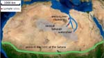 A generalised map of the Sahara shows the location of the sample sites and the fossilised river courses (Credit: Univeristy of Bristol) |
Did ancient river channels guide humans out of Africa ? (Africa) 14 October 2008 The first humans to leave Africa didn't have to struggle over baking sand dunes to find a way out - instead they might have followed a now-buried network of ancient rivers, researchers say. Chemical analysis of snail fossils suggests that monsoon-fed canals criss-crossed what is now the Sahara desert as modern humans first trekked out of Africa. Now only visible with satellite radar (see an image), the channels flowed intermittently from present-day Libya and Chad to the Mediterranean Sea, says Anne Osborne, a geochemist at the University of Bristol, UK, who led the new study. Up to five kilometres wide, the channels would have provided a lush route from East Africa - where modern humans first evolved - to the Middle East, a likely second stop on Homo sapiens' world tour. Archaeological, genetic and palaeontological evidence have pointed to the Nile River Valley and Red Sea as other potential alleys for human migration out of Africa. Watery clues To make a case for the channels, Osborne's team excavated snail fossils buried by half a metre of sand from a channel in Libya and compared their chemical makeup to rocks from volcanoes hundreds of kilometres away. By measuring the decay of a radioactive metal locked into the shells and rocks, Osborne's team showed that the buried snails must have incorporated water that flowed from the volcanoes. Other climate records point to a sometimes-green Sahara around this time, and Osborne thinks that seasonal monsoons could have supported a patchwork of life-saving oases across the desert. Chris Stringer, a palaeoanthropologist at London's Natural History Museum, says Osborne's team makes a good climatological case for the importance of the Saharan channels in human migrations. North African human bones and artefacts closely match those in the Middle East, but, he says, a greener Sahara could have connected already existing populations in both spots to achieve the same effect. Better proof could come with archaeological finds documenting a human migration across the Sahara, he says. Yet it's a task that few researchers have taken on so far. "It's up to the archaeologists now to go and have a search," Osborne says. Source : http://www.newscientist.com/article/dn14935-did-ancient-river-channels-guide-humans-out-of-africa.html
|
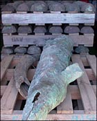 Recovered treasures include copper ingots, ivory and cannons. 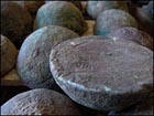 Copper ingots carry a trident seal used by the Fugger family  Portuguese gold coins are part of the recovered cargo |
Uncovering Namibia's sunken treasure (Namibia) 26 September 2008 By Frauke Jensen - BBC News, Oranjemund, Namibia A team of international archaeologists is working round the clock to rescue the wreck of what is thought to be a 16th Century Portuguese trading ship that lay undisturbed for hundreds of years off Namibia's Atlantic coast. The shipwreck, uncovered in an area drained for diamond mining, has revealed a cargo of metal cannonballs, chunks of wooden hull, imprints of swords, copper ingots and elephant tusks. It was found in April when a crane driver from the diamond mining company Namdeb spotted some coins. The project manager of the rescue excavation, Webber Ndoro, described the find as the "the most exciting archaeological discovery on the African continent in the past 100 years". "This is perhaps the largest find in terms of artefacts from a shipwreck in this part of the world," he said. Skeleton coast The ship may have been unable to withstand the currents in the volatile seas off the Namibian shore. The area is also known as the Skeleton Coast and is associated with the skeletons of wrecked ships and past stories of sailors wandering through the barren landscape in search of food and water. Working out whose ship this was is no easy task. Gold coins that the Portuguese crown began producing in October 1525 mean it could not have been the vessel of the famous seafarer Bartholomew Dias, who disappeared on one of his travels around the point of Africa in the year 1500. But there are other pointers, including swivel-guns known to have been used by Portuguese and Spanish seafarers, and the boat's shape, indicating that it was a Portuguese "nau". There are also copper ingots carrying a clearly visible trident seal that can be traced back to the German banker and merchant family of Jakob Fugger - the main suppliers of primary materials to the Portuguese crown. Gold and silver coins have been deposited in a bank vault. Rare navigational instruments have been sent to Portugal for research, while pewter plates and jugs, pieces of ceramic, tin blocks and elephant tusks are temporarily housed in a warehouse on the premises of the mining company. Some are being freed of their layer of sand and salt to allow for more detailed scrutiny over their make and origin. "It represents a very interesting cargo - we have goods from Asia, we have goods from Europe, we have goods from Africa," said Mr Ndoro. "We always think that globalisation started yesterday but in actual fact here we are with something we can date to around 1500." Protected The site is about 130km (80 miles) south of the Namibian harbour town Luderitz, in an area long sealed off for mining. The mines are established by sea-walling the ocean and dredging the dry seabed for diamonds. Pumps ensure the sea does not reclaim the land - an exercise that is costing thousands of dollars each week. Bruno Werz, the archaeologist leading the excavations, said the shipwreck was particularly valuable because it had not been tampered with. "This collection has not been disturbed by human interference," he said. "We are very fortunate to have found an untouched wreck with all the material that was on site still here in one collection." Archaeologists from South Africa, Namibia, Zimbabwe, the United States, the UK and Portugal are working on the excavation, which is due to be completed by mid-October. Thereafter the detailed work of recording and preserving, which can take up to 30 years, can begin. Stone and metal cannonballs and other artefacts are being covered with plastic and sand to protect them from sun and air. Mr Ndoro said the shipwreck was a very important find for Africa. "Here we have different African countries cooperating to make sure we have saved this ship and we have something we can show to the world." "I am sure there will be many more wrecks to be found here," he added. "Namibia should invest in training archaeologists." Source : http://news.bbc.co.uk/2/hi/africa/7634479.stm
|
|
Namibian Portuguese shipwreck hailed as one of the best (Namibia) 23 September 2008 ORANJEMUND: A treasure-laden 16th-century Portuguese vessel that ran aground off Namibia's coast was hailed by archaeologists yesterday as providing a rare insight into the heyday of seafaring explorations between Europe and the Orient. "This is a cultural treasure of immense importance," Bruno Werz said when offering journalists a first glimpse of the precious find at the excavation site in Namibia's diamond-rich "sperrgebiet" or no-go zone. The shipwreck, which was discovered by geologists dredging for diamonds in April, is the oldest found in sub-Saharan Africa. Werz's team of scientists are from Namibia, the US, Portugal, South Africa and Zimbabwe. It was thought that the ship was linked to Bartholomew Diaz, the first European to round the Cape of Good Hope, in 1488, but some of the ship's 2 000 gold coins were dated October 1525, 25 years after Diaz disappeared. A Portuguese archaeologist described it as the best-preserved example of Portuguese seafaring outside Portugal. With diamond mining company Namdeb spending vast amounts to keep the sea at bay while the excavations take place, pressure is on the team to finish the work by early next month. - Sapa-dpa Source : http://www.themercury.co.za/index.php?fArticleId=4624653
| |
 The obelisk was surrounded by scaffolding for reassembly |
Ethiopia unveils ancient obelisk (Ethiopia) 4 September 2008 Ethiopia is celebrating the unveiling of the reassembled Axum obelisk, one of the country's greatest treasures. The obelisk, at least 1,700 years old, was looted by Italian troops in the 1930s and returned to Ethiopia in 2005. A giant Ethiopian flag was removed from the obelisk in front of what organisers said was a crowd of tens of thousands in the ancient northern town of Axum. The ceremony is the last big event of Ethiopia's millennium year, the year 2000 by the country's Coptic calendar. The president and prime minister were among the officials attending. Ancient empire Intricately carved obelisks were erected at the tombs of Ethiopia's ancient kings when Axum was the centre of a great empire. But only one remained standing amid the tumbled blocks of its former companions, the BBC's Elizabeth Blunt reports from Ethiopia. The Axum obelisk was taken by troops in 1937 during the Italian occupation. The monument weighs more than 150 tonnes and was brought back from Italy in three pieces. Its return followed decades of negotiations between the Italian and Ethiopian governments, and long delays in transporting the heavy stones from Rome. The monument has now been restored and resurrected in its original home. It had been lying on the ground for centuries when the Italians found it, and some archaeologists argued it should have been replaced in that position to avoid damage to it or nearby networks of underground tombs. But others have said Ethiopians should be able to see the obelisk in its original position. Ethiopia's ambassador to the UK, Berhanu Kebede, told the BBC's Network Africa programme that the obelisk would help his country "to build a stronger and vibrant nation". "We have fought a protracted battle to bring back our historical asset, and this is very important because it's a manifestation of who we are and it also shows what our ancestors have done," he said. "The obelisk shows the architectural talent of our ancestors and modern architects are fascinated how the Ethiopians were able to do that during that period." Source : http://news.bbc.co.uk/2/hi/africa/7597589.stm
|
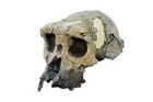 AFP/MPFT/File Photo: Undated handout photo shows the 3D reconstruction of the skull of Toumai. |
Finder of key hominid fossil disputes 7-million-year dating (Chad) 1 September 2008 PARIS (AFP) - A fresh storm has broken out over an ancient fossil presented by its defenders as a forebear of humanity and dismissed by its critics as the remains of a vulgar chimp. Controversy has swirled around Toumai, the name given to the nearly-complete skull, ever since it was found in the Chadian desert in 2001. Toumai's big defender is French palaeontologist Michel Brunet, a professor at the prestigious College de France, who says Toumai walked the Earth shortly after chimpanzees and hominids diverged from a common ancestral primate. Brunet has been roundly attacked in other quarters. Critics are incensed that he has given a hominid honorific (Sahelanthropus tchadensis) to a creature whose cranium, in their view, was too squashed to be that of a pre-cursor of Homo sapiens. They calculate that Toumai's height was no more than 120 centimetres (four feet) -- or that of an adult chimpanzee. Brunet appeared to have scored a knockout blow in February this year, when radiological measurements estimated that the soil where Toumai was found was between 6.8 million and 7.2 million years old. The study appeared in a top-line US journal, the Proceedings of the National Academy of Sciences. But the man who discovered Toumai, Alain Beauvilain, of the University of Paris at Nanterre, has now publicly challenged this estimate. Beauvilain declined to take part in the hominid-vs.-chimp debate, but said he questioned the dating's methods and the way it had been presented to the public. "It's time to set the record straight," he told AFP. In general, radiodating of the sediment in which a fossil is found is considered to be a good guide to when the creature died, its remains eventually becoming covered by soil or other debris. But Beauvilain, a Chadian fossil expert of long standing, says that, contrary to Brunet's assertions that the fossil had been "unearthed," the cranium was found loose on the sand. A thick blue ferruginous, or iron-based, mineral encrusted the skull, which showed clear signs of weathering from desert conditions, Beauvilain says in a commentary in the South African Journal of Science. Beauvilain says it is clear that the soil around the find, and possibly the find itself, had been shifted by wind or erosion, a phenomenon that can happen swiftly and frequently in the desert. So carbon-dating the soil and attributing that to the skull was a perilous exercise, he says. "How many times was it exposed and reburied by shifting sands before being picked up?" he asks in the commentary. Beauvilain also takes issue with the soil samples used for the PNAS study and analysed by experts from France's National Centre for Scientific Research (CNRS). He says these samples were taken selectively and did not give a full picture of the depth and range of topography in which the find was made. He describes some of the collection choices as "astonishing." On the same grounds, Beauvilain attacks Brunet's dating of an ancient Chadian jawbone, dubbed Abel and estimated to be between three million and 3.5 million years old. "Abel," too was picked up on the surface in 1995, and was not embedded in the soil, he says, showing photos of both finds on their day of discovery. The debate is important because of its implications for anthropology. Toumai -- the name means "hope of life" in the local Goran language -- was found 2,500 kilometers (1,500 miles) west of the Great Rift Valley, until now considered the cradle of humanity. So if the skull's dating is right, it implies the early hominids ranged far wider from East Africa, and far earlier, than previously thought. The discovery also implies hominids evolved quickly from apes after they split from a common primate ancestry. Hominids are considered the forerunners of anatomically modern humans, who appeared on the scene about 200,000 years ago. Still unclear, though, is the exact line of genealogy from these small, rather ape-like creatures to the rise of the powerfully-brained Homo sapiens. Source : http://news.yahoo.com/s/afp/20080901/sc_afp/sciencefrancechadpalaeontology_080901235847;_ylt=AtuQ4SAUN3kbuGa8u_t5M31FeQoB
|
|
Earliest Known Human Had Neanderthal Qualities (Ethiopia) 22 August 2008 The world's first known modern human was a tall, thin individual -- probably male -- who lived around 200,000 years ago and resembled present-day Ethiopians, save for one important difference: He retained a few primitive characteristics associated with Neanderthals, according to a series of forthcoming studies conducted by multiple international research teams. The extraordinary findings, which will soon be outlined in a special issue of the Journal of Human Evolution devoted to the first known Homo sapiens, also reveal information about the material culture of the first known people, their surroundings, possible lifestyle and, perhaps most startling, their probable neighbors -- Homo erectus. "Omo I," as the researchers refer to the find, would probably have been considered healthy-looking and handsome by today's standards, despite the touch of Neanderthal. "From the size of the preserved bones, we estimated that Omo I was tall and slender, most likely around 5'10" tall and about 155 pounds," University of New Mexico anthropologist Osbjorn Pearson, who co-authored at least two of the new papers, told Discovery News. Pearson said another, later fossil was also recently found. It too belonged to a "moderately tall -- around 5'9" -- and slender individual." "Taken together, the remains show that these early modern humans were...much like the people in southern Ethiopia and the southern Sudan today," Pearson said. Building On Leakey's Work Parts of the Omo I skeleton were first excavated in 1967 by a team from the Kenya National Museums under the direction of Richard Leakey, who wrote a forward that will appear in the upcoming journal. Leakey and his colleagues unearthed two other skeletons, one of which has received little attention. Two of the three skeletons found at the site have been a literal bone of contention among scientists over the past four decades. Reliable dating techniques for such early periods did not exist in the late 60's, and the researchers could not agree upon the identity of the two skeletons. From 1999 to the present, at least two other major expeditions to the southern Ethiopian site -- called the Kibish Formation -- have taken place, with the goal of solving the mysteries and learning more about what the area was like 200,000 years ago. As evidenced by photographs showing the researchers followed by armed guards, work at this location proved challenging. "It took us five plus days to get there from Addis," paleobiologist Josh Trapani of the Smithsonian Institution and the University of Michigan told Discovery News. "Once there, we had intense heat, hyenas outside camp, crocodiles in the river, many insects and two remarkable and very different groups of people, the Mursi and the Nyangatom on opposite sides of the river who were our partners in some of this work." Primitive, Yet Still Like Us The ordeals proved successful, as the scientists have recovered new bones for Omo I, some of which perfectly fit into place with the remains Leakey unearthed over 40 years ago. Several scientists analyzed the bones, including a very detailed, comparative look at the shoulder bone by French paleontologist Jean-Luc Voisin. They concluded that, without a doubt, Omo I represents an anatomically modern human, with bones in the arms, hands and ankles somewhat resembling those of other, earlier human-like species. "Most of the anatomical features of Omo are like modern humans. Only a few features are similar to more primitive hominids, including Neanderthals and Homo erectus," explained John Fleagle, distinguished professor in the Department of Anatomical Sciences at Stony Brook University in New York. "Omo II is more primitive in its cranial anatomy," he added, "and shares more features with Homo erectus and fewer with modern humans." Unlikely Neighbors New dating of the finds determined that Omo II lived at around the same time and location as Omo I, indicating that Homo sapiens may have coexisted with Homo erectus, a.k.a. "Upright Man," who is believed to have been the first hominid to leave Africa. Fleagle explained the detailed nature of the latest dating techniques that place both skeletons at around the 200,000-year-old period. He said both skeletons were recovered from rocky geological layers, with "Adam" unearthed just above a layer of volcanic rock. Precise dates can then be calculated because "when volcanic rocks form, they start a radiometric clock that ticks at a regular rate." Fleagle added, "By looking at the ratio of parent minerals and daughter minerals you can calculate when the rocks were initially formed." Source : http://dsc.discovery.com/news/2008/08/22/earliest-human-ethiopia.html
| |
|
Tanzania: Prehistoric Weapons Factory (Tanzania) 3 August 2008 THE ISIMILA STONE AGE SITE in Tanzania provides fascinating insights into how ancient man developed the tools to master his environment. Stone tools and artefacts found at Isimila near Iringa town, over 500 kilometres from Dar es Salaam, show that the Hehe -- one of the ethnic groups in the region -- used the site as a sort of Stone Age weapons factory. Excarvation in Iringa region, especially Mtera and Upper Kihansi, indicate that there were settlements in these areas from as early as 200,000 years ago to as late as the Iron Age. According to Mohammed Ngoma, a conservationist at the Isimila Stone Age Site, Upper Kihansi too was a production site for stone tools of the Neolithic period, which include pot shards and remains of iron works. The Iron Age settlements in Iringa district and rock paintings at Kombangulu in Kilolo district also provide fascinating glimpses into the lives of early humans. The Isimila site is reputed to have been inhabited from 300,000 to 400,000 years ago. The soil erosion that has been occurring there over the millennia, has uncovered remains of stone tools, animals and plants that have contributed to the understanding of the pre-history of the area. The stone tools currently preserved at Isimila include knives, slingshots, stone hammers, hand axes, scrapers, and spears. A magnificent "Mgoha" spear on display at the site, for instance -- made in the year 1700 by the Hehe ethnic group -- was donated to the site by one Zuberi Mwamwitala. SUCH TOOLS AND WEAPONS served to protect the people from enemies -- both human and animals as well as to hunt animals for food. The Isimila site was discovered in 1951 by D.A McCleman of Saint Peters School in Johannesburg. On his way from Nairobi to Johannesburg, he collected some stone tools from the site and deposited them with the Archaeological Survey Union of South Africa. The first excavation works at the site were done from July to November 1957, followed by another excavation from July to August 1958. During these two excavations, a detailed geological survey of Isimila was carried out and Dr Louis Leakey became the first researcher to examine the fauna remains recovered from the two excavations. The Isimila Stone Age Site is one of the richest exposures of Stone Age tools in Africa. According to Mr Ngoma, Stone Age implements found at the site are called Acheulian type because they are similar to implements found at St Acheal in France. Similar implements, which are estimated to be as much as half a million years old have also been found at Olduvai Gorge. The Acheulian tradition worldwide is known to date from about 1.5 million years ago. Erosion at Isimila has exposed many layers of soil and rocks of different types, marking the different historical periods. The tools are made from a variety of rocks such as granite and quartzite. Fossils found in the area suggest the existence of animals such as elephants, a variety of extinct pigs, giraffe and hippo. ARCHAELOGICAL RECORDS from Iringa indicate that the area had contact with the outside world by the 15th century. The ultimate control of the areas by outsiders started with the onset of Germany as a colonial power in 1891. The Germans arrived in Tanganyika in 1885 and established their capital in Bagamoyo district, some 45 kilometres from Dar es Salaam. From there, they started to consolidate their rule along the coast. This colonial venture ignited resistance by the people of the Coast. People like Abushiri (in 1888 to 1889) and Bwanaheri (from 1889 to 1894) resisted the German invasion. In Uhehe, now Iringa, German troops arrived in 1891. When Chief Mkwawa of the Hehe was informed of this, he immediately sent his solders to Lugalo to prevent them from approaching his capital at Kalenga. In August 17, 1891, Mkwawa's solders ambushed the Germans at Lugalo. The Germans were defeated and their leader, Zelewinsky, was killed. The name Lugalo was later used by the Tanzania Peoples' Defence Forces for one of its biggest barracks. Zelewinsky's pyramid shaped tomb, where he was buried along with a number of his solders, is still to be seen at Lugalo, a few metres from the Tanzania-Zambia highway. The Germans sent troops again in 1894 under new leadership. Mkwawa continued with his resistance for several years until he shot himself in 1898 to avoid being captured by the Germans. After the First World War, the Germans were defeated and their colonies placed under British authority. On independence in 1961, Adam Sapi Mkwawa, the grandson of Chief Mkwawa, became the first African Speaker of the Tanzanian National Parliament. Source : http://allafrica.com/stories/200808190350.html
| |
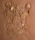 SAHARAN BURIAL - The skeletons of a woman and two children are the first triple burial uncovered in Africa, researchers say. Preserved in this cast exactly as found, the skeletons were part of the oldest Stone Age graveyard in the Sahara |
Saharan surprise : A Stone Age graveyard offers insights into two poorly understood cultures (Niger) 14 August 2008 Investigators searching for dinosaur fossils in the Sahara in 2000 suddenly took an unexpected and scientifically exciting leap backward in time. They came upon a stretch of sand littered with the bones of ancient people positioned in ways characteristic of intentional burials. Investigations of the bones and associated finds made since that fateful discovery show that they come from the largest and oldest Stone Age graveyard in the Sahara, team members report online in the Aug. 14 PLoS ONE. They also described their findings August 14 during a press briefing held at the National Geographic Society in Washington, D.C., which partly funded the excavations. The Gobero archaeological site, which dates to as early as 10,000 years ago, lies in the western African nation of Niger. The area had already gained fame earlier when excavation director and paleontologist Paul Sereno of the University of Chicago found 110-million-year-old dinosaur fossils nearby. Work at Gobero indicates that two successive human populations divided by 1,000 years lived by a lake, perhaps seasonally, during a time of regular Saharan rainfall. These hunter-gatherer groups buried their dead in separate gravesites by the lake, leaving an unprecedented biological and material record of their poorly understood cultures. Although hunter-gatherer groups are typically mobile and small in number, those living in resource-rich areas tend to stay for long periods at seasonal sites, comments anthropologist Henry Harpending of the University of Utah in Salt Lake City. “It’s interesting that at Gobero these ancient populations became dense enough to require large cemeteries,” he says. Excavation seasons in 2005 and 2006 have revealed 200 graves. Human and animal bones, as well as bone artifacts, have yielded 78 radiocarbon dates, which are based on ratios of different isotopes of carbon in the bones and artifacts. “I’ve never seen an archaeological site that’s as exceptional as Gobero is,” archaeologist and team member Elena Garcea of the University of Cassino in Italy said at the press briefing. The older Gobero group, members of the Kiffian culture, hunted large game and speared two-meter-long perch with bone harpoons. They colonized the Sahara from 10,000 to 8,000 years ago, when heavy rains created a deep lake at Gobero. Pottery pieces at the site are decorated with zigzags and wavy lines already linked to the Kiffians, Garcea says. Kiffians buried dead individuals with their legs pulled up tightly against their body, suggesting that the deceased were bound up with some type of wrapping. Both adult males and females often reached two meters in height. The later Gobero residents, from the Tenerian culture, hunted small game using tiny stone arrowheads, caught small catfish and tilapia and herded cattle. The Tenerians inhabited the site from 7,200 to 4,200 years ago, when it featured a shallow lake. Parallel lines of impressed dots cover Tenerian pottery. Tenerians were shorter and had slighter builds than Kiffians did. Tenerians often buried their dead with jewelry and placed them in ritual poses. The 4,800-year-old skeleton of a girl lying on her side, with arms and legs slightly bent, includes an upper-arm bracelet carved from a hippo’s tusk. Based on her bone development, the researchers estimate that the girl was 11 years old when she died. The most striking find occurred in 2006, when the researchers uncovered what they say is Africa’s first triple burial. A petite, 40-year-old Tenerian woman lay on her side, facing two children, an 8-year-old and a 5-year-old. Their entwined arms reached out and their hands clasped in what Sereno’s team calls the “Stone Age embrace.” These individuals died from undetermined causes 5,300 years ago. Source : http://www.sciencenews.org/view/generic/id/35314/title/Saharan_surprise
|
 The boat is entirely wooden and has only one sail 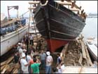 The vessel was designed from archaeological evidence  Local boatmakers said they had never done anything like it before |
Around Africa in a Phoenician boat 9 August 2008 On Arwad Island off the coast of Syria, a group of 20 sailors-to-be are preparing for a voyage their captain believes has not been undertaken for two and a half millennia. They plan to set off on Sunday on a journey that attempts to replicate what the Greek historian Herodotus mentions as the first circumnavigation of Africa in about 600BC. Their vessel, the small, pine-wood Phoenicia, is modelled on the type of ship the Phoenician sailors he credited with the landmark voyage would have used. The Phoenicians lived in areas of modern-day Lebanon, Syria and other parts of the Mediterranean from about 1200BC and are widely credited with being both strong seafarers and the first civilisation to make extensive use of an alphabet. Mammoth project Celebrating Damascus as a capital of Arab Culture for the year 2008, event organisers sponsored the British-run expedition project to mark their festivities. The year-long voyage will take the crew into some of the most dangerous waters in the world. As well as sailing round the southern most tip of Africa, they are preparing to deal with pirates and long periods of waiting for favourable winds. The skilful shipbuilders in Arwad are familiar with construction techniques dating back 200-300 years, but shipbuilder Orwa Bader, 28, says this is the first time they have ever tried to build in the Phoenician style. "Usually it takes three men and two months to build any type of ship. But this time, we needed at least five to 10 builders to work on it over eight months to make it ready. It was a hard but enjoyable job." The vessel, designed on the basis of information from wrecked ships, pottery and other archaeological artefacts from the era, is made entirely of wood, with a single sail and no engine. The only concession to 21st Century sailing equipment is its navigational system. Its top speed will be the equivalent of 10km/h on land. Piracy fears The route goes through the Red Sea, past Somalia and down the East African cost before rounding the southern tip of Africa around Christmas time. The ship's skipper, Philip Beale, planned the voyage. "The most difficult part will be circumnavigating around the Cape of Good Hope where many shipwrecks are testimony to the difficult conditions there. You can get big waves of 20 metres or more there. It is a dangerous area and we'll be there in December and January." He predicts they have a 70% chance of completing the voyage successfully. "But there's a 30% chance we make a serious navigational error or we come up against pirates and we are kidnapped or something," he adds. Few luxuries The ship will be crewed by a largely British team of volunteers, some of whom have never done anything similar. Living conditions will be tough, and little different from those the Phoenicians would have endured. The experience will be new for John Bainbridge, 23: "It's about how you get on with people. That's the most essential skill," he says. And Julia Rouc, 26, originally from Zimbabwe, is hoping to spend time reading and possibly continue developing her aspirations to become a professional artist. "I am excited about it. It is a great experience. I am used to living in tough conditions so it is all fine by me. But I am not sure if I will have time to continue painting." Below deck, it feels extremely hot. There will be no ventilation and no running water, and one toilet for the 20 crew members. Their bunks are barely big enough to lie in. Unlike the Phoenicians' ships, the vessel will be equipped with lifeboats, and will carry large amounts of food and fresh water. But just like the ancient sailors, the crew will not really know how the boat will fare until it hits the open sea. Source : http://news.bbc.co.uk/2/hi/middle_east/7550162.stm
|
 |
Genetic Evidence Used To Trace Ancient African Migration (southern Africa) 5 August 2008 Stanford University researchers peering at history's footprints on human DNA have found new evidence for how prehistoric people shared knowledge that advanced civilization. Using a genetic technique pioneered at Stanford, the team found that animal-herding methods arrived in southern Africa 2,000 years ago on a wave of human migration, rather than by movement of ideas between neighbors. The findings shed light on how early cultures interacted with each other and how societies learned to adopt advances. "There's a tradition in archaeology of saying people don't move very much; they just transfer ideas through space," said Joanna Mountain, PhD, consulting assistant professor of anthropology. Mountain and Peter Underhill, PhD, senior research scientist in genetics at Stanford's School of Medicine, were the study's senior authors. Their findings will appear in the Aug. 5 advance online edition of Proceedings of the National Academy of Science. "We know that humans had to migrate at some point in their history, but we also know humans tend to stay put once they get someplace," Underhill said. Instead of using archaeological evidence alone to guess whether people migrated, "all of a sudden, with genetics, you can actually address that question," Mountain said. The researchers tracked genetic variation on the Y chromosome, the sex chromosome passed from father to son that encodes maleness, using a technique now widely used that was developed in the early 1990s by Underhill and colleagues in the lab of Luigi Cavalli-Sforza, professor emeritus of genetics. The method has given scientists a powerful window into ancient human migrations and prehistoric cultural shifts. The technique has also been adopted by some commercial genealogy services that offer Y-chromosome testing to the public. Previous research suggested that prehistoric people in eastern and southern Africa had little contact, with only two known migrations between the regions about 30,000 and 1,500 years ago. After Bantu-language speakers migrated from eastern to southern Africa 1,500 years ago, agriculture took off in southern Africa. But the timing of the Bantu migration didn't quite match the 2,000-year-old anthropological evidence for the first sheep and cattle herds in southern Africa, so anthropologists were unsure whether the region's agricultural knowledge came from a bow-wave of ideas that spread in front of the migrating Bantu, or whether a separate migration brought the first herders. "Africa has the most genetic diversity in the world, but it is one of the least-studied places," said Brenna Henn, a doctoral student in anthropology who was the study's lead author. "I've always felt like there were a lot of stories there that nobody's had the time or interest to look into." The Stanford scientists picked the Y sex chromosome to examine for clues to migration because it changes very little from one generation to the next. Autosomes - the non-sex chromosomes - come in pairs, and the members of a pair can exchange bits of DNA during reproduction, making each autosome a mishmash of DNA from all of an individual's ancestors. But the Y chromosome is a singleton; males inherit one Y chromosome and one X chromosome, while women have two X chromosomes. In men, only a tiny region of the Y chromosome can swap DNA with the X chromosome. This means almost all of the Y chromosome moves intact from father to son, changing only infrequently when a new mutation arises. That allows researchers to examine several generations of ancestry by looking at the Y chromosomes of living men. "The family tree of the Y chromosome is very, very clear," Mountain said. The team analyzed Y chromosomes from men in 13 populations in Tanzania in eastern Africa and in the Namibia-Botswana-Angola border region of southern Africa. They discovered a novel mutation shared by some men in both locations, which implied those men had a common ancestor. Further analysis showed the novel mutation arose in eastern Africa about 10,000 years ago and was carried by migration to southern Africa about 2,000 years ago. The mutation was not found in Bantu-speakers, suggesting that a different group - Nilotic-language speakers - first brought herds of animals to southern Africa before the Bantu migration. This new genetic evidence correlates well with pottery, rock art and animal remains that suggest pastoralists - herders who migrated to new pasture with their flocks - first tended sheep and cattle in southern Africa around 2,000 years ago. The genetic finding also helps explain linguistic similarities between peoples in the two regions. "I like the fact that the linguistic, genetic and archaeological evidence all line up," Henn said. "When you see lines of evidence converge on a single model, it means that's probably something that actually happened." Underhill and Roy King, MD, PhD, associate professor of psychiatry and behavioral sciences, published a similar paper in the June issue of the journal Antiquity. That study used Y chromosome evidence to examine how climate change drove prehistoric migration in the Middle East. They found that a shift in rainfall 10,000 years ago propelled a cultural split among genetically related people. Some stayed in rainy areas and grew crops, while others moved to arid regions and lived the nomadic life of pastoralist herders. The groups didn't intermingle much after the split, perhaps explaining the origins of modern Middle Eastern cultures. Genetic evidence gives a degree of clarity to the study of prehistoric migration that's hard to achieve in other ways. "So rarely do we get to pin down the questions raised by archaeology," Mountain said. Henn, Mountain and Underhill collaborated with scientists at the Stanford Genome Technology Center; the University of Regensburg, in Germany; Sapienza Università di Roma, in Italy, and the University of Maryland. The research was supported by grants from the National Science Foundation, the National Institutes of Health, the Wenner-Gren Foundation, the Leakey Foundation and BayGene (the Bavarian Genome Network). Source : http://www.sciencedaily.com/releases/2008/08/080804190635.htm
|
 The Grand Mosque at Djenne, Mali. The area's rich cultural heritage is only being slowly discovered  Teams digitize rare works in the new studio in Timbuktu - nuamps.at.northwestern.edu/ timbuktu  A private family library in the Tuareg village of Ber, 40 miles east of Timbuktu  The historical trans-Saharan trading routes |
The Rush to Save Timbuktu's Crumbling Manuscripts (Mali) 1 August 2008 Fabled Timbuktu, once the site of the world's southernmost Islamic university, harbors thousands upon thousands of long-forgotten manuscripts. A dozen academic instutions from around the world are now working frantically to save and evaluate the crumbling documents. Bundles of paper covered with ancient Arabic letters lie on tables and dusty leather stools. In the sweltering heat, a man wearing blue Muslim robes flips through a worn folio, while others are busy repairing yellowed pages. An astonishing project is underway in Timbuktu, Mali, one of the world's poorest countries. On the southern edge of the Sahara Desert, experts are opening an enchanted Aladdin's Cave, filled with hundreds of thousands of ancient documents. The Ahmed Baba Library alone contains more than 20,000 manuscripts, including works on herbal medicine and mathematics, yellowed volumes of poetry, music and Islamic law. Some are adorned with gilded letters, while others are written in the language of the Tuareg tribes. The contents remain a mystery. Manuscript hunters are now scouring the environs of Timbuktu, descending into dark, clay basements and climbing up into attics. Twenty-four family-owned collections have already been discovered in the area. Most of the works stem from the late Middle Ages, when Timbuktu was an important crossroads for caravans. It was home to gold merchants and scholars, and it even boasted a university with 20,000 students. The old saying "the treasures of wisdom are only to be found in Timbuktu" summed up the ancient city's appeal. But the legacy of the oasis, written with ink made from gallnuts, is beginning to fade. Roughly a dozen academic institutions are now involved in saving and evaluating the documents. The French are developing a database, while the United States has donated a device to digitize the damaged documents. The Norwegian cities of Oslo and Bergen are training locals to become conservators. Shamil Jeppie, a Cape Town historian charged with managing the multinational effort, recently published a book, "The Meanings of Timbuktu," in which he describes the current status of the project. European colonialists suppressed the "intellectual history of West Africa," Jeppie writes, and now it is time to rediscover the site that some have referred to as an "African Oxford." Hunting for Mali's Hidden Documents This is an astonishing assessment, given Timbuktu's status as a desert town in the middle of nowhere. In 1825, a European managed to navigate the difficult route down to a bend in the Niger River, south of the Sahara. By the time he reached the oasis, he had run out of water and was barely alive. Shortly after entering the city he was murdered. Timbuktu was taboo -- off-limits to Christians. Even today, Timbuktu is not an easy place to get to. From August to February, local riverboats called pinnaces bob their way up the Niger River, landing at the port town of Kabara, 10 kilometers (6 miles) from Timbuktu. The landscape is dominated by sand dunes until shortly before the city's suburbs. The desert wind known as the Harmattan is about as pleasant as a dragon's breath. And yet the old section of the city is blanketed in an odd, heavy magic, filled with mosques topped by bulbous minarets and wealthy citizens' opulent houses, cube-shaped buildings with meter-thick walls made of baked clay. According to an employee at the Ahmed Baba Library, Mali was overrun by the French colonial army after 1880. "The French didn't want us to have the manuscripts, and they tried to steal them," says the library worker. The documents were hidden to protect them. But now the hunt is on. The house of Ismael Haidara, a historian whose ancestors include the Visigoths and jungle kings from southern Mali, has proven to be a treasure trove. Haidara, a private citizen, horded more than 2,000 bundles of papers, passed down through 11 generations of his family. "This is our family history," he says, pointing to a leather slipcase from the year 1519. Albrecht Hofheinz, an Arabist from Oslo, estimates that there are up to 300,000 forgotten manuscripts in Mali. Insect bites have discolored the pages, he says. "The paper disintegrates, is destroyed by mold or eaten by termites." Time is of the essence. Some of the volumes are being photographed using a digital photo studio provided by the University of Chicago. The first of the documents are expected to be available on the Internet by the end of the year. The contents of astronomical documents are already being analyzed. "So far 112 texts on astronomy have been discovered," explains Petra Schmidl, a historian of science at the University of Frankfurt am Main. They include calendar calculations, astrology and a depiction of the Ptolemaic world system. Researchers are now looking forward to studying the tattered archives that contain reports on ancient oases and nomadic societies. The manuscripts also include lists of goods transported by caravans. Will the documents finally shed some light on the mysterious caravan trade? There are many questions on how the trade thrived in the desert. The world's largest desert stretches 2,000 kilometers (1,242 miles) from north to south. How did the caravans make it through? Archaeologists have not even scratched the surface at the caravans' destinations in Ghana and the Ivory Coast. But they have uncovered new finds in the Sahara, including traces of an ancient infrastructure. Water storage facilities have been found in the middle of the vast desert, as well as places fed by underground wells. Desert palaces once built by the Tuareg were unearthed in the Essouk oasis in northern Mali. It is now clear that the Arabs were the first to conquer the inhospitable arid zone. While Rome's legions ventured no further than the edges of the desert, they penetrated far deeper into the Sahara. There is evidence of a Moorish influence in Ghana by as early as 800 A.D. Vast gold deposits were found in the Ghanaian rain forest. Their owners, the Soninke kings, ruled a realm that stretched to the banks of the Senegal River. Point of Departure for Desert Journeys According to Arab accounts, the black rulers lived in tents guarded by large dogs wearing gold and silver collars and manacles. According to Arab geographer al-Bakir, one of these kings commanded an army of 200,000 soldiers. The country provided cola nuts, ivory, cotton and semiprecious stones. Local traders loaded their goods onto cargo boats and transported them on the Niger to Timbuktu. The city was the point of departure for journeys into the desert. Camels stood at Timbuktu's water troughs. Its residents included Arabs, light-skinned Berbers and dark-skinned members of the Malinke tribe. The oasis smelled of lamb dung and fresh spices, and muezzins called out from its minarets. Gold, a form of payment, glistened everywhere -- as dust, nuggets and fist-sized lumps. In 1324, when Kankan Mussa, one of the kings of Mali, went on a pilgrimage to Mecca, via Cairo, with his ostentatious entourage, he was so generous with the precious metal (he had brought along two tons of it) that gold prices on the Nile plunged. News of the wealthy black monarch even reached faraway Europe. A Catalan map of the world depicts him with thick lips and holding a scepter. Kankan was so impressed by the palaces of the Orient that he brought home an architect, who created malleable mud-brick imitations of the Arab mosques in Timbuktu. The Djingerber Mosque, with its sugarloaf-shaped towers, still stands in the city today. The historical trans-Saharan trading routes. There is an even larger mosque in nearby Djenne, part fairytale castle and part termite hill. Each year after the rainy season, when cracks have formed in the outside walls, hundreds of workers participate in what has become a national pastime cum religious service. Men climb up along wooden scaffolding in the outside walls, praying as they climb, to apply fresh mud to the structure. For many years, such customs were all but unknown in Europe (US ethnologist Susan Vogel filmed the annual mud plaster ceremony last year for the first time). In the past, those traveling to Timbuktu had to traverse seemingly endless volcanic plains and rocky plateaus -- at temperatures of up to 55 degrees Celsius (131 degrees Fahrenheit). The area south of Murzuk, an oasis notorious for its role in the slave trade, consists of a vast, shimmering sand bowl measuring 90,000 square kilometers (34,700 square miles, or about the size of Portugal). Anyone who lost his way there was literally baked. The Arabs only managed to complete the journey through the desert with the help of camels. A camel can drink 200 liters of water at a time, and its kidneys retrieve large amounts of water after urination. The Arabs also enlisted the help of the Tuareg tribes, which lived on ridges in the central Sahara. Even there, surrounded by hyper-arid sand pans, volcanic basalt chimneys and pinnacles, life was possible. The Tuareg drilled deep wells, and they had their black slaves excavate long underground canals with slight inclines to bring in ground water. Archaeologists have shown that an incredible system of underground canals up to 20,000 kilometers (12,422 miles) long once existed at Wadi al-Hayat in Libya. Thanks to such hydraulic marvels, the desert blossomed and crops sprouted in the fields of the Tuareg. In Essouk, they ate gazelles and dried perch, imported from the Niger River, 240 kilometers away. Murzuk, with its large slave market, was surrounded by a massive wall with seven gates -- in the middle of the Sahara. A Source of African Pride But nothing worked without the blue-robed Tuareg. They provided provisions for the caravans and led them to the oases. At times, they turned to blackmail and looting, and Timbuktu was attacked several times. Researchers are anxious to discover more about the haggling between ethnic groups and how they divided up the spoils. In the late Middle Ages, Cairo was sending 12,000 camels a year to Mali. There were plenty of fortunes to be made. The slave trade was especially lucrative. Guards carrying whips drove the slaves through the hot desert. "Only the youngest and strongest survived the two-month desert trek, and they were walking skeletons by the time they reached the Fezzan region, where they were fattened up," writes Austrian geographer Hans Weis. The Koran also made its way into sub-Saharan Africa along these torturous routes. In its heyday, Timbuktu had 180 Koran schools. "A large library was built, where the fundamental theological and philosophical works were copied," explains Thomas Krings, an Africa expert at the University of Freiburg in southwestern Germany. The many documents that were penned then are now emerging in Mali as crumbling volumes. "Many people consider Timbuktu to be the end of the world," says Mahamoudou Baba Hasseye, the owner of a valuable private collection, "but it was an important center of Islamic scholarship." Calligraphers once plied their trade in the desert. Some of the manuscripts uncovered in Timbuktu contain gold lettering, and some are written in the unusual Songhai and Fulfulbe tribal languages. These treasures are still a long way from being saved. The libraries are filled with bits and pieces of paper, evidence of crumbling manuscripts. The government of South Africa promised to build a library in Timbuktu years ago, but nothing ever came of it. But at least there are many who have come to Timbuktu to help save its ancient manuscripts. The project, which historian Petra Schmidl characterizes as being on the "extreme fringe of the Islamic academic community," is a source of great pride for Africans. "Africa has repeatedly been portrayed as culturally inferior," says Essop Pahad, South Africa's Minister in the Presidency. "In Timbuktu, we are proving that the opposite is true." Translated from the German by Christopher Sultan Source : http://www.spiegel.de/international/world/0,1518,569560,00.html
|
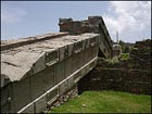 The Great Obelisk - the largest of all - still lies in the area  |
Restoring Ethiopia's great obelisk (Ethiopia) 21 July 2008 The slender stone columns which mark the tombs of ancient kings and nobles still stand in a green field at the edge of the modern town of Axum. But these days the site is dominated by a huge tower of scaffolding, topped by a yellow mobile crane, which dwarfs King Ezana's obelisk, the one royal monument still standing. Inside the scaffolding lies part of the Axum Obelisk, looted by Italian troops in 1937 during their brief occupation of Abyssinia. Italy returned the 1,700-year-old monument in 2005, after decades of negotiations between the two countries. The obelisk, which weighs more than 150 tonnes, was taken back to Ethiopia in three pieces. Now it is being restored and resurrected back in its original home. Unique At the moment an ugly fence of corrugated iron screens off the working area. But if you get inside, you can see the first chunk of the Rome obelisk already in place, in the centre of the scaffolding tower. It has been firmly cemented into its new foundations, exactly where it stood in antiquity. The remains of the old foundations lie nearby - huge blocks of stone cut to fit the base of the monument. When the work is done they will be placed alongside so visitors can see the how things were done before the days of cranes and concrete. The base of the column is a huge block of grey granite, carved - as if it was the ground floor of a tall building - with the unmistakable image of a door, complete with a ring-shaped door handle. One of the most astonishing things about these monuments is that they appear to mimic the facades of multi-story buildings. Fisseha Zibelo, from Ethiopia's ministry of culture, says this carving shows the imagination of the monuments' creators. "We know they had two- and three-storey buildings, because in Axum there are big buildings with more than one storey, " he said, "but here they were imagining the skyscrapers of the future." The two other sections of the obelisk are still lying nearby on concrete supports. It is a unique opportunity to get close to them, to see the sharp clarity of the details, nearly 2,000 years after they were first carved. You can see the window frames of the imaginary building, and the round beam-ends protruding from the walls in characteristic Axumite building style. Protective collar The middle section is due to be hoisted into place soon and is almost ready to go. The work is being done by an Italian firm, Lattanzi. Site supervisor Mauro Cristini describes the whole project as experimental work. "Nobody anywhere has ever done anything like this." But he says that although the middle section is massively heavy, it is in good condition, solid apart from a mended break at one corner. That is not the case with the upper section, which is much more fragile. The slender peak of the column, with its famous curved top, was already broken, and was struck by lightning in Rome, damaging it still further. Mr Cristini's workers are painting on a protective coating before fitting it with a strong collar - effectively a handle for the crane to hold onto while raising it into position. The whole project to raise the obelisk has been quite controversial. It was lying on the ground when the Italians found it, and had been on the ground for centuries. Some archaeologists think it should have been replaced in that position. Not only is there the risk of damage to the obelisk itself during the work, but they worry that the new foundations could disturb the complex of underground tombs which lies beneath the monuments, and which has only recently begun to be explored. And then there is the risk to King Ezana's column, the one carved royal monument which has stood since antiquity, and which is very close to the construction works. It already leans at a slight angle, and has been braced with steel hawsers to prevent it being damaged by the vibration caused by the heavy equipment. It is regularly monitored, and Mr Cristini says that although some slight movement has been recorded, it has not been enough to cause concern. The whole team - Ethiopian and Italian - are impatient to see the obelisk finally in place. The last section should be placed in position in early August, ready for an official ceremony on the fourth of September, just before the end of Ethiopia's millennium year. Pride of place "This monument was made by our ancestors" says Fisseha Zibelo. "It's only in Axum that this kind of monument was made, so for us, it is a matter of pride and mark of our identity." As for Mr Cristini, he says for him this is a little bit of history. "The circle is closed now," he says. "Before it was on the ground, but now the people of Ethiopia will be able to see it on its original site, so everything is going to be even better than before." Source : http://news.bbc.co.uk/2/hi/africa/7505957.stm
|
|
Tanzania: Prehistoric Footprints Stir Fresh Controversy (Tanzania) 21 July 2008 Archaeological experts are divided on a plan to exhume the hominid footprints at Laetoli for public display, some arguing that this could lead to erosion of the rare imprints. The 3.6 million- year old footprints, discovered in 1978, have since the 1990s been reburied for protection while a replica of the original cast is on display at the site. Government authorities recently intended to exhume the oldest known footprints of human ancestors for public view in order to attract more tourists and researchers. An assistant conservator of Antiquities now in charge of the facility, Mr Geoffrey ole Moita, told The Citizen last weekend that there was a possibility that the footprints would be brought to the land surface for public view. He said President Jakaya Kikwete, who visited the area recently, expressed his concern that the archaeological relics have been preserved in a grave-like monument. "The president directed a team of local experts to exhume them from their likely permanent grave for the sake of both tourism and studies on human evolution", he explained. However, he said no conclusive decision had been made on the fossilised imprints of early hominids which were discovered by Dr Mary Leakey 30 years ago. The late British-born Kenyan scientist also played a key role in the discovery of the famous Zinjathropous skull at the nearby Olduvai Gorge in 1959 alongside her late husband, Louis. With the assistance of scientists from Getty Conservation Institute of Los Angeles in the US, the track-way was reburied in 1995 to save it from erosion. But this has been criticised by some experts. The original track was covered by fine silicone rubber which made it impermeable to water and other materials. A copy of the original cast is on display at the site and the Olduvai Gorge museum. Critics say reburying the world's oldest hominid footprints was not the best option to preserving them because they could neither be seen by visitors nor other interested parties. Getty Institute scientists and officials of the department of Antiquities in the Ministry of Natural Resources and Tourism say the 20-metre long track way was buried because it had started to deteriorate with continued exposure after its discovery in 1978. Both the Laetoli and Olduvai Gorge sites are within the Ngorongoro Conservation Area whose officials support the government's plans to have the footprints exposed for public view. The acting conservator, Mr Bernard Murunya, says the Ngorongoro Conservation Area Authority was ready to set aside funds to uncover the footprints as the president directed. "The site is set to become an additional tourist attraction and we expect even more tourists to flock here to view the tracks," he said. Source : http://allafrica.com/stories/200807220050.html
| |
|
Ancient Egyptian boat to be excavated, reassembled (Egypt) 19 July 2008 Archaeologists to excavate hundreds of fragments of 4,500-year-old ancient Egyptian wooden boat. Archaeologists will excavate hundreds of fragments of an ancient Egyptian wooden boat entombed in an underground chamber next to Giza's Great Pyramid and try to reassemble the craft, Egyptologists announced Saturday. The 4,500-year-old vessel is the sister ship of a similar boat removed in pieces from another pit in 1954 and painstakingly reconstructed. Experts believe the boats were meant to ferry the pharaoh who built the Great Pyramid in the afterlife. Starting Saturday, tourists were allowed to view images of the inside of the second boat pit from a camera inserted through a hole in the chamber's limestone ceiling. The video image, transmitted onto a small TV monitor at the site, showed layers of crisscrossing beams and planks on the floor of the dark pit. "You can smell the past," said Zahi Hawass, director of Egypt's Supreme Council of Antiquities. Experts will begin removing around 600 pieces of timber in November, said professor Sakuji Yoshimura of Japan's Waseda University, who is helping lead the restoration effort with the antiquities council. The discovery of the boat pits more than 50 years ago by workmen clearing a large mound of wind-blown debris from the south side of the Great Pyramid is considered one of the most significant finds on the plateau. They are the oldest vessels to have survived from antiquity. The reconstructed ship is on display in a museum built above the pit where it was discovered. It is a narrow vessel measuring 142 feet with a rectangular deckhouse and long, interlocking oars that soar overhead. The cedar timbers of its curved hull are lashed together with hemp rope in a technique used until recent times by traditional shipbuilders along the Red Sea, Persian Gulf and Indian Ocean. The unexcavated boat, made from Lebanese cedar and Egyptian acacia trees, is thought to be of similar design, but smaller and less well preserved. John Darnell, an Egyptologist at Yale University, said new research into the second boat could fill in some blanks about the significance of the vessels and help determine whether they ever actually plied Nile River waterways or were of purely spiritual import. "In Egypt, almost everything real had its counterpart meaning or significance in the spiritual world. But there's a lot of debate as to whether these vessels ever were used or not," Darnell said. Those who argue the vessels may have touched water point to rope marks on the wood that could have been caused by the rope becoming wet and then shrinking as it dried. But Hawass believes these were symbolic vessels, not funerary boats used to bring the pharaoh Khufu's embalmed remains up the Nile from the ancient capital of Memphis for burial in the Great Pyramid, the oldest and largest of Giza's pyramids. He said solar symbols found inside the second pit offer more evidence that those who disassembled and buried the boats believed Khufu's soul would travel from his tomb in the pyramid through a connecting air shaft to the boat chambers and that he would use the boats to circle the heavens, like the sun god, taking one boat by day and the other by night. Source : http://www.middle-east-online.com/english/culture/?id=27003
| |
|
Heritage dig yields Zulu artefacts (South Africa) 17 July 2008 By Sharika Regchand An archaeological dig at Zulu King Dingane's former royal residence at uMgugundlovu has unearthed artefacts dating to the mid-19th century. These were an iron spearhead and coloured glass beads. Piles of charcoal were also found. The excavation was undertaken by Amafa, KwaZulu-Natal's heritage body, to locate the outer palisade of an oval-shaped homestead of about 1 500 beehive-shaped, grass-covered dwellings enclosing an open area where the king used to inspect his army and Nguni cattle. Amafa CEO Barry Marshall said: "Now that we are aware of the extent of the king's residence, the other perimeter will be planted with indigenous aloes, which will make a spectacular ring of colour during winter." The site was 30km from Ulundi, off the road between Melmoth and Vryheid and in the heart of the eMakhosini Valley, where many Zulu kings were buried, said Marshall. It was also adjacent to the R25 million multimedia centre being built as a place of reconciliation and to showcase four centuries of Zulu history. At the site, Dingane had ordered the killing of Voortrekker leader Piet Retief and his party on February 4, 1838. They were buried on nearby kwaMatiwane, the Hill of Execution. After the ensuing Battle of Blood River, when the Zulus were defeated by the Boers, Dingane left his residence, ordering it to be burned. "An archaeological dig during the 1970s exposed circular fire-baked mud-and-dung floors, and some dwellings have been reconstructed, including the king's personal home," he said. UMgungundlovu was closed to the public during construction of the multimedia centre. "Foundations for the multi-media centre have been completed and it is due to open early in 2008. It is intended as the departure point for visits to the cultural, historical and natural attractions of the 30 000ha eMakhosini/Opathe Heritage Park," said Marshall. Source : http://www.int.iol.co.za/index.php?set_id=1&click_id=588&art_id=vn20080717062206113C334626
| |
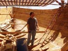 |
Historic Africa circumnavigation starts 1 August 11 July 2008 More than 2,500 years after the first circumnavigation of Africa by the Phoenicians, a brand new replica ship with 20 paying crew is preparing to follow in the footsteps of these ancient mariners. According to the Greek Historian, Herodotus, in 600 BC, Phoenician mariners achieved the first circumnavigation of Africa in a 21-metre square-rigged ship with around 10 rowing stations on each side. Philip Beale, a City fund manager turned adventurer, arranged for a team of Syrian boat builders to begin construction of a replica Phoenician ship in 2007. The 17,000 mile historical voyage will begin from Syria on 1 August with 20 paying crew aboard. After navigating down the east coast and tackling the Cape of Good Hope, the boat will return up the west coast, through the straits of Gibraltar and across the Med back to Syria, followed by a trip to the UK in summer 2009. "The journey will be long... The challenges will be great... But the rewards will be inspiring and unforgettable." is the message for the crew, who will be braving some of the most dangerous coastlines on earth in an open boat with little shelter. Philip Beale has previous experience with such a journey. In 2003, he set sail aboard the Borobudur, a recreation of another historical voyage from Indonesia to Africa. For more information about the Phoenicia Expedition, please visit: www.phoenicia.org.uk Source : http://www.ybw.com/auto/newsdesk/20080611150353pbogeneral.html
|
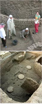 Parts of an administration building, above, and a large silo, top, at the site of an ancient provincial capital on the Upper Nile. |
Uncovering Evidence of a Workaday World Along the Nile (Egypt) 1 July 2008 Archaeologists have long fixed their sights on the grandeur that was ancient Egypt, the pyramids, temples and tombs. Few bothered to dig beneath and beyond the monumental stones for glimpses into the living and working spaces of ordinary Egyptians. Parts of an administration building, above, and a large silo, top, at the site of an ancient provincial capital on the Upper Nile. That is changing slowly but steadily. In the last two or three decades, excavations have uncovered urban remains and swept aside the conventional wisdom that the Egypt of the pharaohs, in contrast to Mesopotamia, was somehow a civilization without cities. “We can now confirm that this was not the case,” said Nadine Moeller, an Egyptologist at the Oriental Institute of the University of Chicago. Dr. Moeller was speaking of her own recent findings, as well as those of other excavators who practice what is known as settlement archaeology. She described the discovery of a large administration building and seven grain silos buried at the site of an ancient provincial capital on the Upper Nile. The partly preserved round silos, more than 3,500 years old, appear to be the largest storage bins known from early Egypt. Seal impressions and other artifacts associated with commodities put a somewhat older date for the central building, with at least 16 columns. An official announcement of the discovery was made by Zahi Hawass, secretary general of the Supreme Council for Antiquities in Egypt. He is best known for the more spectacular research on mummies and tombs, but is now promoting greater attention to settlement exploration. “This is a really amazing site, at the cutting-edge of recent Egypt archaeology,” said Stuart Tyson Smith of the University of California, Santa Barbara, who was not involved in the project. “Digging into towns, you get the full range of life, not the very narrow view of society as seen from the top, from the rich and elite.” Mark Lehner, an Egyptologist who uncovered remains of settlements for workers who built the pyramids at Giza, said that at Dr. Moeller’s site he inspected layers of sediments showing occupation extending back 5,000 years to the dawn of Egyptian civilization and forward to the early Islamic period in the first millennium A.D. The silos are near temple ruins from about 300 B.C. “Where there are temples, we are learning, they were surrounded by towns which have usually been overlooked,” Dr. Lehner said. The site of the recent discovery is at Tell Edfu, halfway between the modern cities of Aswan and Luxor (Thebes in antiquity). For much of Egyptian history, the central government was based in Memphis, in the north, or Thebes. The town at Tell Edfu was an important regional center with close ties to Thebes. Dr. Moeller and a team of European and Egyptian archaeologists began excavations near the temple there in 2005. They exposed a large courtyard surrounded by mud-brick walls. Underneath the courtyard, they came upon foundations of the first three of the seven silos. From artifacts, the archaeologists dated the silos to the 17th dynasty, 1630 to 1520 B.C. These storage bins, presumably for barley and emmer wheat, which were used for food and as a medium of exchange, were built of mud brick, with diameters from 18 to 22 feet. If their height was greater than the diameter, as was the usual case, the silos probably stood at least 25 feet tall. “Their size was a surprise, nothing we had encountered before, certainly not in a town center,” Dr. Moeller said. In the last three years, the team excavated the column bases and chambers of what they think was the town’s administrative center. The building layout suggests it may have been part of the governor’s palace, and artifacts mark it as the economic heart of town. Seal impressions, which established the building’s existence in the 13th dynasty, 1773 to 1650 B.C., indicate their use in identifying different commodities. Some seals showed ornamental patterns of spirals and hieroglyphic symbols belonging to different officials. Archaeologists said this was evidence of the activities in the building like accounting and the opening and sealing of boxes and ceramic jars in the course of business transactions. “The work at Edfu is important in that it allows us to examine ancient Egypt as an urban society,” said Gil Stein, director of the Oriental Institute. As a specialist in Mesopotamian archaeology, Dr. Stein noted the longstanding assumption that the valley of the Tigris and Euphrates Rivers was “a land of cities and Egypt was something else, because in Egypt we had not been looking at or for cities.” Egyptologists credit Manfred Bietak of the University of Vienna, Barry Kemp of Cambridge University in England and Dr. Lehner, now with Ancient Egypt Research Associates in Boston, as leaders in nudging excavators toward research into everyday urban life along the Nile. “It’s a smallish club, but gaining converts,” Dr. Smith said. Source : http://www.nytimes.com/2008/07/01/science/01egyp.html?_r=1&ref=todayspaper&oref=slogin
|
|
Newcomer in Early Eurafrican Population? (Morocco) 30 June 2008 A complete mandible of Homo erectus was discovered at the Thomas I quarry in Casablanca by a French-Moroccan team co-led by Jean-Paul Raynal, CNRS senior researcher at the PACEA[1] laboratory (CNRS/Université Bordeaux 1/ Ministry of Culture and Communication). This mandible is the oldest human fossil uncovered from scientific excavations in Morocco. The discovery will help better define northern Africa's possible role in first populating southern Europe. A Homo erectus half-jaw had already been found at the Thomas I quarry in 1969, but it was a chance discovery and therefore with no archeological context. This is not the case for the fossil discovered May 15, 2008, whose characteristics are very similar to those of the half-jaw found in 1969. The morphology of these remains is different from the three mandibles found at the Tighenif site in Algeria that were used, in 1963, to define the North African variety of Homo erectus, known as Homo mauritanicus, dated to 700,000 B.C. The mandible from the Thomas I quarry was found in a layer below one where the team has previously found four human teeth (three premolars and one incisor) from Homo erectus, one of which was dated to 500,000 B.C. The human remains were grouped with carved stone tools characteristic of the Acheulian[2] civilization and numerous animal remains (baboons, gazelles, equines, bears, rhinoceroses, and elephants), as well as large numbers of small mammals, which point to a slightly older time frame. Several dating methods are being used to refine the chronology. The Thomas I quarry in Casablanca confirms its role as one of the most important prehistoric sites for understanding the early population of northwest Africa. The excavations that CNRS and the Institut National des Sciences de l'Archéologie et du Patrimoine du Maroc have led there since 1988 are part of a French-Moroccan collaboration. They have been jointly financed by the French Ministry of Foreign Affairs[3], the Department of Human Evolution at the Max Plank Institute in Leipzig (Germany), INSAP[4] (Morocco) and the Aquitaine region. [1] De la Préhistoire à l'Actuel : Culture, Environnement et Anthropologie (From Prehistory to Present day: Culture, Environment, and Anthropology) [2] Acheulians appeared in Africa around 1.5 million years ago and disappeared about 300,000 years ago, giving way to Middle Stone Age civilizations. Their material culture is characterized by the production of large stone fragments shaped into bifacial pieces and hatchets, and of large sharp-edged objects. [3] (Mission archéologique « littoral » Maroc, led by J.P. Raynal).[4] (INSAP-Rabat) which falls under the authority of the Moroccan Ministry of Cultural Affairs. Source : http://www.alphagalileo.org/index.cfm?fuseaction=readrelease&releaseid=530382&ez_search=1
| |
|
Coils of Ancient Egyptian Rope Found in Cave (Egypt) 20 June 2008 The ancient Egyptian's secret to making the strongest of all rigging ropes lies in a tangle of cord coils in a cave at the Red Sea coast, according to preliminary study results presented at the recent congress of Egyptologists in Rhodes. Discovered three years ago by archaeologists Rodolfo Fattovich of the Oriental Studies University of Naples and Kathryn Bard of Boston University, the ropes offer an unprecedented look at seafaring activities in ancient Egypt. "No ropes on this scale and this old have been so well preserved in their original context -- in Egypt or elsewhere," Bard told Discovery News. Carefully wrapped in coils by ancient Egyptian sailors almost 4,000 years ago, the ropes were found in a hand-hewn cave at the ancient Red Sea port of Marsa Gawasis, 23 kilometers (14 miles) south of Safaga. "The cave is really spectacular. Over 30 coils of ropes lie on the ground as if they had just been left there. Amazingly, these ropes were stored in the same way as nowadays sailors store their shipping cords -- just coiling and tighting them in the middle," archaeologist and rope analyst Andre Veldmeijer told Discovery News. Most of the coils were recovered from the back of the cave. There are at least two layers of ropes. In their report, Veldmeijer and colleague Chiara Zazzaro of the University of Naples, estimated that more than 60 complete coils of cords are stored in the long, deep cave. "Each cord is about 30 meters (98 feet) long and is very thick. No doubt these ropes were made for strong, heavy duties, Veldmeijer said. "Basically, they were hauling truss components. They ran above the deck, secured at the bow and at the stern, to produce structural cohesion for the ship," The theory is supported by the fact that the estimated length of the Egyptian ships is about 10 meters (33 feet) shorter than the ropes' lengths. This shows that sailors had five meters (16 feet) at both ends to tie the ropes. The researchers are still puzzling over the material the ancient Egyptians used to make such a strong cordage. "It's really intriguing. We know that the ropes are made of vegetable fibers only," Veldmeijer said. "Moreover, they are of one type of vegetable fiber -- Egyptians never used different materials together to make ropes. We can exclude the usual, known materials, such as halfa grasses, papyrus and palm. It's possibly reed... We hope to solve the puzzle by the end of the year." Meanwhile, excavation work at Marsa Gawasis continues. The site abounds with man-made caves cut into the rock. They all seem to be filled with seafaring remains. "We found remains of ship timbers, anchors, expedition equipment, cargo boxes and pottery. Analysis has shown that these caves contain the world's oldest maritime artifacts," Fattovich said. As for the ropes, the researchers believe they are the well-preserved riggings from an Egyptian seafaring expedition to the fabled Land of Punt (around present-day Somalia), in the 12th Dynasty, almost 4,000 years ago. "We found hieroglyphic texts about these expeditions, and even some materials brought back from Punt, such as ebony, obsidian and pottery from eastern Sudan, Eritrea and Yemen," Bard said. The most famous expedition to the mysterious and exotic Land of Punt was conducted during the reign of Queen Hatshepsut and is described in bas-relief inscriptions in her funerary temple at Deir el-Bahri. "We are now excavating the harbor area. Other ship remains are coming to light. This is such an important site. There is much more to discover," Fattovich said. Source : http://dsc.discovery.com/news/2008/06/20/rope-cave-egyptian.html
| |
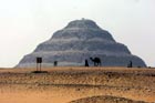 |
Mapping Djoser's Step Pyramid (Egypt) 19 June 2008 A laser scanning survey is the latest technology used to record the recent state of Egypt's oldest royal stone complex, Sunrise at Saqqara, and all is well on the necropolis. It is, as usual, silent, peaceful and still out here in the desert. Last Tuesday, however, the serenity and divinity were broken by the arrival of an American-Japanese scientific mission to carry out a laser scanning survey of Djoser's Step Pyramid. At the footsteps of the pyramid were gathered dozens of people, from scientists to technicians, archaeologists and restorers to workmen, all there to witness the first ever endeavour to document, in detail, the present condition of the great and distinctive monument using a high-tech laser device in an attempt to create a virtual three-dimensional model of Egypt's oldest pyramid complex. Carried on the backs of three professional climbers as they grappled to descend all four faces of the pyramid's six gigantic steps, the Zoser Scanner, a device created specially for the purpose, records data at the exceedingly fast rate of 40,000 points per second using infrared signals to gather coordinates and elevations of thousands of points on the monument. "It is an archaeological salvage project," Culture Minister Farouk Hosni told Al-Ahram Weekly. He explained that such a project would not only provide a detailed map of the Step Pyramid but would also create a virtual three-dimensional model of it, which in its turn will be a valuable reference for architects, restorers and archaeologists involved in the restoration of the pyramid and for the continual monitoring of its condition. Zahi Hawass, secretary-general of the Supreme Council of Antiquities (SCA), says the project falls within the framework of the commitment made by the Ministry of Culture and the SCA to protect and preserve Egypt's cultural and archaeological heritage. He points out that the survey is being conducted in collaboration with a Japanese mission headed by Kosuke Sato of Osaka University and an American mission led by Mark Lehner, director of Ancient Egypt Research Associates (AERA). This project intends on completing the archaeological documentation of the Step Pyramid in order to better understand its various stages of construction. A variety of laser scanners will be used, including the Zoser Scanner, which was custom designed to scan the pyramid by Develo Solutions of Osaka, Japan. Sato pointed out that for more than 70 years French architect Jean-Philippe Lauer had comprehensively studied and restored the Step Pyramid complex. Although his seminal work was indisputably considered the foundational study on pyramids, his theories were based on his schematic plans and sections, which are not facsimiles of the actual state of the monument. In contrast to the scanned images produced by the ground fixed laser scanner in the previous season, Sato continued, the Japanese mission improved several aspects for laser scanning the Step Pyramid in order more evenly to dense point cold data, eliminating shadows created by obstacles between the laser scanner and the target as much as possible and providing a density of point clouds finer than 5mm mesh. Sato said that he did not arrive haphazardly at the invention of a special device, but that it was an urge because the normal fixed laser scanner produced uneven point cloud data which were needlessly very dense at closer ranges, while less dense at a distance. "The developed scanner maintains a constant distance between the scanner and the pyramid," he said. To avoid having an unscanned area, Yukinori Kawae from the AERA explained, the mission applied a multiple scanner system that simultaneously produced laser beams, even behind small protuberances. With this method, while surveyors scan and move at a constant speed, accurate information for the position and the attitude of the scanners can be gained. The laser scanning survey of the Step Pyramid will take four weeks to complete, and next year the second phase for the pyramid's internal structure will start. The Step Pyramid was built during the reign of King Djoser of the Third Dynasty (2687-2668 BC). It is the first pyramid in Egyptian history, and the earliest stone structure of its size. Over the years, the six steps of the pyramid have been exposed to natural erosion leading to their deterioration, and now a comprehensive restoration project is taking place in an attempt to save this great pyramid. Source : http://weekly.ahram.org.eg/2008/902/he2.htm
|
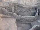 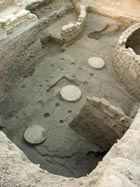 |
When grain was currency (Egypt) 19 June 2008 A large administrative building and silos thought to be the largest grain bins from the ancient Egyptian era ever found are the latest discoveries at Tel Edfu. Nevine El-Aref reports on a site that is providing fresh clues about the emergence of urban life in ancient times "Ancient Egyptian administration is mainly known from texts, but the full understanding of the institutions involved and their role with towns and cities has been so far difficult to grasp because of the lack of archaeological evidence with which textual data needs to be combined," says Nadine Moller, assistant professor at the Oriental Institute of Chicago University and head of the archaeological mission in Tel Edfu. At Tel Edfu, Moller says, the mission has uncovered what is considered to be a downtown centre, a community located half way between the modern city of Aswan and Luxor. Tel Edfu was also a rare example where almost 3,000 years of ancient Egyptian history are still preserved in the stratigraphy of a single mound. Last year the mission revealed details of a seven silos and an older columned hall, which was an administration centre. "These monuments were found at the core of the ancient community as grain was a form of currency at that time, while the silos functioned as a sort of bank as well as a food source," Moller said, adding that the size of both the silos and administration buildings shows that the community was apparently a prosperous urban centre. "Grain, which was usually barley or emmer wheat, was used as food and medium of exchange. One form of payment was the monthly ration of grain," Moller said. Zahi Hawass, secretary-general of the Supreme Council of Antiquities (SCA), says the grain bins the mission found this year are in a large silo courtyard dating back to the 17th Dynasty (1630-1520 BC) and containing at least seven round mud-brick silos measuring 5.5x6.5 metres in diameter, making them the largest example so far discovered within a town centre. The team also uncovered an earlier building phase for the hall, one that predates the silos. In that phase, Hawass said, a mud-brick building with 16 wooden columns stood on the site. "The pottery and seal impressions found in the hall are dated to the early 13th Dynasty, while the layout of the building shows that it may perhaps have been part of a governor's palace, which was a typical feature of provincial towns," Hawass said. Moller told Al-Ahram Weekly that there was no exact parallel for such a columned hall being part of the administrative buildings. The columned hall was the place where the scribes would possibly do the accounting, the opening and sealing of the containers, and receive letters. "The ostraca or inscribed pottery shards found have lists of commodities written on them," she said, adding that the team also found seal impressions that were used for different types of objects. Some were seals for papyrus documents, while others were for wooden boxes and baskets. "The seals were like scarabs, showing ornamental patterns such as spirals and a mix of hieroglyphic symbols such as ankhs," Hawass said. Patterns belonging to different officials were also found, providing much evidence of the administrative activities that once took place there such as accounting and the opening and sealing boxes, ceramic jars and other commodities. The period when the administrative centre was in use is the time in history when Egypt lost its political unity and a small kingdom developed in Thebes which controlled most of Upper Egypt. During this period one can see an increase in connections between the provincial elite, such as the family of the governor, to the royal family at Thebes who were keen on strengthening bonds through marriage or by awarding important offices to these people. "It is exactly at this period when Edfu seems to have been very prosperous which can now be confirmed further by archaeological discoveries such as this silo-court, a symbol of the wealth of the town," Moller said. Source : http://weekly.ahram.org.eg/2008/902/he4.htm
|
|
Workers unearth ancient tools (South Africa) 18 June 2008 A piece of ancient history revealed itself to modern society when prehistoric tools were unearthed during the excavation of a swimming pool at a Pretoria school last week. The discovery was made while workers were preparing the ground for a swimming pool at Waterkloof House Preparatory School in Muckleneuk. The tools are believed to date back at least 100 000 years when prehistoric man roamed the Pretoria area. While showing a Pretoria News team around the site, another stone tool, believed to be from the same era, was unearthed. Dr Francis Thackeray, director of the Transvaal Museum, said the discoveries were a clear sign that ancient man existed in the area at least 100 000 years ago, "long before the arrival of Jan van Riebeeck even". He said the discoveries, which also include a stone brought in from another area, clearly showed signs of human behaviour. Thackeray said the tools, which have been flaked in several places to form a cutting edge, probably would have been used to break animal bones to get at the marrow. The marrow is likely to have been an important source of protein to supplement a prehistoric diet of roots, tubers, fruit and insects, said Thackeray. He said the tools were similar to those he had discovered at other sites such as Kromdraai in the Sterkfontein valley, in the Cradle of Humankind. It is not the first time that Thackeray has discovered stone tools at the school. When he was a pupil there 50 years ago, he found several stone tools while the school's cricket field was being levelled. Asked what the chances of members of the public finding such tools in the Pretoria area were, Thackeray said they were extremely good, "especially in the Brooklyn area, which would have been occupied by small populations of prehistoric man". The latest find is to join the collection of stone artifacts found 50 years ago at the school's museum, where they will now be on public display. Source : http://www.int.iol.co.za/index.php?set_id=1&click_id=588&art_id=vn20080618060428205C997417
| |
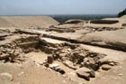 The long-lost foundations of an ancient Egyptian pyramid (pictured) have been found at the royal burial grounds of Saqqara, archaeologists announced on June 5, 2008. Hidden by sand for generations, the newly excavated structure may hold the tomb of a pharaoh, Menkauhor, who ruled more than 4,000 years ago. |
"Lost" Pyramid Found Buried in Egypt (Egypt) 5 June 2008 The pyramid of an ancient Egyptian pharaoh has been rediscovered after being buried for generations, archaeologists announced today. (See photos and video.) The pyramid is thought to house the tomb of King Menkauhor, who is believed to have ruled in Egypt's 5th dynasty for eight years in the mid-2400s B.C. Long since reduced to its foundations, the structure was previously known as Number 29 or the "Headless Pyramid." It was mentioned in the mid-19th century by German archaeologist Karl Richard Lepsius. Then it disappeared in the sands of Saqqara, a sprawling royal burial complex near current-day Cairo. It took Egyptian archaeologists about a year and a half just to remove all the sand above the pyramid. "After Lepsius the location of the pyramid was lost and the substructure of [the] pyramid never known," said Zahi Hawass, secretary general of Egypt's Supreme Council of Antiquities. "It was forgotten by people until we began to search this area and a hill of sand, maybe 25 feet [7.6 meters] high." Hawass is a National Geographic explorer-in-residence. (The National Geographic Society owns National Geographic News.) Old Kingdom Clues Nothing on the pyramid specifically names its owner, and the majority of the structure has been destroyed, so Egyptian archaeologists had to put several clues together to identify it. Past archaeologists have disputed the date of the pyramid, usually putting it in either the Old Kingdom, between 2575 and 2150 B.C., or the Middle Kingdom, between 1975 and 1640 B.C. But the recent research determined that the pyramid lacked the winding mazes typical of a Middle Kingdom temple. Instead, the lack of artwork and inscriptions, as well as the structure's red granite blocks, were typical of Old Kingdom pyramids, according to Hawass. The burial chamber also contained the lid of a sarcophagus made of gray schist, a type of rock often used in the Old Kingdom. What's more, the newfound pyramid resembles the pyramid next to it, which belongs to the first pharaoh of the 6th dynasty, Teti, who ruled from 2345 to 2181 B.C. That suggested the lost pyramid could also come from the 5th dynasty. The neighboring pyramid also pointed to the owner of the pyramid as Menkauhor, since he was without a discovered burial tomb. "There were missing pyramids of the kings, and this is one of them," Hawass said. Sacred Road Archaeologists also announced the discovery of new parts of a sacred road, dating to the Ptolemaic period, some 2,000 years after the Old Kingdom. The discovery shows the sustained importance of Saqqara, which was located in the ancient capital of Memphis, the researchers added. Ola El Aguizy is a professor of ancient Egyptian languages at Cairo University. "During the whole history of Egypt, Memphis and Saqqara had remained very, very important," El Aguizy said. "I am discovering tombs of people of the 26th dynasty [in Saqqara] that were reusing tombs of the 19th dynasty. It is a sacred place, and so many important people wanted to be buried there." Another reason people wanted to be buried in Saqqara was the sacred road, which was used for the procession of mummified bulls of the god of the dead, Osiris. "[Osiris] was enthroned like a king and when he died they made funerals like those of a king," El Aguizy said. The bulls also had a historical significance: Their deaths were used to determine when a pharaoh reigned. "It's a way of dating the pharaohs," El Aguizy said. "Sometimes we know how many bulls died during the reign of a king, or vice versa." More Discoveries Expected The sacred path, first discovered by French archaeologist Auguste Mariette in 1850, is nicknamed the Way of the Sphinxes because of its long row of statues often found at the gates of Egyptian temples. "The modern name of ancient Memphis is Mit Rahina … which means the way of the Sphinx," El Aguizy said. "So [this path is] presumably the Way, with sphinxes [formerly] on the two sides." Archaeologists hope the path will lead to more discoveries in the area. Plans are underway to relocate modern-day workers who live in a village beside the Menkauhor site to allow an expanded search for more temples. "When I say we've discovered 30 percent of the Egyptian monuments, I take Saqarra as the first example," Hawass said. "Saqqara is a virgin site," he added. "It's very important for us to do this excavation to understand more about the pyramids of the Old Kingdom." Source : http://news.nationalgeographic.com/news/2008/06/080605-new-pyramid.html
|
|
Little arrow that rewrites history books (South Africa - Sibudu cave, KwaZulu Natal) 5 June 2008 By Shaun Smillie It might have been used to bring down a small blue duiker or perhaps pick off a bird high in the forest canopy. Its exact target will never be known, but scientists now know what this ordinary-looking piece of bone was used for. Two researchers from Wits University believe that what they have discovered is a 60 000-year-old arrow that was fired from the earliest known bow. Their discovery has pushed back the origins of bow-and-arrow technology by 20 000 years. The bow, probably made of wood and long since decayed, was used at a time when Neanderthals in Europe were using large spears in duels with woolly mammoths and other large prehistoric game. Dr Lucinda Backwell of the Bernard Price Institute for Palae-ontological Research and Professor Lyn Wadley of Wits University's department of archaeology and Institute for Human Evolution released their findings in an article that appeared in the Journal of Archaeological Science co-authored by Francesco d'Errico of the University of Bordeaux in France. The bone arrow, just 5cm long, was excavated by Wadley at the Sibudu cave, near the coastal town of Ballito in KwaZulu Natal, two years ago. Wadley handed the specimens, which included two other pieces of bone, to Backwell. It was after much research and visits to Museum Africa in Newtown, Joburg, that Backwell realised what she was looking at. "The museum has a large collection of Bushman arrow points. It appeared to be identical to arrows that the Bushman used to kill birds and small mammals," Backwell said. "We think that the bone point marks a shift from hand-delivered spears to the use of projectile technology." It also provides a glimpse of how humans were living in this corner of what is now KwaZulu Natal. "They would have adapted to living in the forest, where they would have been hunting little animals," she said. "Nets and traps were also probably used for hunting and fishing." The other two bone specimens discovered at the cave also give clues to life 60 000 years ago. Backwell explained: "One of the bones appeared to have been used as a needle, which suggests leather-work. The other bone was highly polished, also suggesting it was used to work leather." It's mystery who the people were who fashioned the arrow. It is not known if these were a new group of people who moved into the area, or if it was technological innovation brought on by environmental changes. Also at this time, humankind was leaving an ever-increasing archaeological record of the first inklings of modern human behaviour. They were burying the dead, using coloured pigments and wearing jewellery. "This at a time a few thousand years before they walked out of Africa, to become the ancestors of all humans," said Backwell. Source : http://www.int.iol.co.za/index.php?set_id=1&click_id=588&art_id=vn20080605055841569C413057
| |
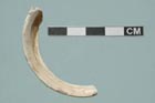 A fragment of a bangle made of a shell found only at the Red Sea suggests possible trade links with the cradle of agriculture in the Near East. (Credit: Copyright UC Regents) |
Egypt's Earliest Agricultural Settlement Unearthed (Egypt) 18 February 2008 Archaeologists from UCLA and the University of Groningen (RUG) in the Netherlands have found the earliest evidence ever discovered of an ancient Egyptian agricultural settlement, including farmed grains, remains of domesticated animals, pits for cooking and even floors for what appear to be dwellings. The findings, which were unearthed in 2006 and are still being analyzed, also suggest possible trade links with the Red Sea, including a thoroughfare from Mesopotamia, which is known to have practiced agriculture 2,000 years before ancient Egypt. "By the time of the Pharaohs, everything in ancient Egypt centered around agriculture," said Willeke Wendrich, the excavation's co-director and an associate professor of Near Eastern languages and cultures at UCLA. "What we've found here is a window into the development of agriculture some 2,000 years earlier. We hope this work will help us answer basic questions about how, why and when ancient Egypt adopted agriculture." Just centimeters below the surface of a fertile oasis located about 50 miles southwest of Cairo, the UCLA-RUG team excavated domestic wheat and barley and found the remains of domesticated animals -- pigs, goats and sheep -- along with evidence of fishing and hunting. None of the varieties of domesticated animals or grains are indigenous to the area, so they would have to have been introduced. The archaeological team also found a bracelet made of a type of shell only found along the Red Sea, suggesting a possible trade link with the cradle of agriculture in the Near East. In addition, they unearthed clay floors of what may have been simple structures -- possibly posts with some kind of matting overhead. In the 1920s, British archaeologist Gertrude Caton Thompson found traces of the same domesticated grains in storage pits less than a mile from the current site. After the advent of carbon-dating technology, the grain was dated to 5,200 B.C., making the discovery the earliest evidence of agriculture in ancient Egypt. To this day, no earlier evidence of agriculture has been found in Egypt. But because no surrounding settlement was ever excavated, all kinds of questions remained about the context in which agriculture began to unfold in ancient Egypt. "We had evidence that there was agriculture by 5,200 B.C. but not how it was used in a domestic context," said excavation co-leader René Cappers, a professor of paleobotany at the University of Groningen, the second-oldest university in the Netherlands. "Now, for the first time, we have domesticated plants and animals in a village context." The latest findings date to the Neolithic period, a stage of human development that occurred at various times around world, beginning in 8,600 B.C. Sometimes called the New Stone Age, the period is characterized by the introduction of farming, animal husbandry and a movement away from hunting and gathering and toward a less nomadic way of life, with pots, tools and settlements. Few clues have been found of Egypt's Neolithic past in the Nile Valley, possibly because they were either buried under silt from the Nile or wiped away when the river changed its course, the archaeologists said. The UCLA-RUG excavation site is located just outside the river valley in what is now a desert region. With more than three feet of undisturbed strata at the site, the team expects to be able to piece together the evolution of domestication in the area between 5,200 B.C. and about 4,200 B.C. "The arrival of the entire Neolithic package in ancient Egypt has always been treated as a moment in time, but we're finding stratified layers that will allow us to tease out the development of agriculture in this area as it developed over the course of hundreds of years," said Wendrich, who is one of the core faculty members at UCLA's Cotsen Institute of Archaeology. Called the Fayum, the oasis where the team is working was surrounded by prehistoric sites, most of which were excavated in the 1920s. Generations of archaeologists had written off the area, until the UCLA-RUG team decided to re-explore the site. "We knew that the settlement existed, but the site had been under cultivation since the 1960s, so archaeologists assumed it had been destroyed," Wendrich said. "We got to this site in the nick of time." Modern laser-leveling farming techniques were about to annihilate the site in 2006, but the archaeological team succeed in rescuing the six-acre plot for future research by renting it for a year while they conducted their initial fieldwork. In the meantime, Egypt's Supreme Council of Antiquities has taken steps to permanently protect the site. The research was funded by the National Geographic Society, UCLA, RUG and private donors on the Directors Council of Cotsen Institute of Archaeology. Source : http://www.sciencedaily.com/releases/2008/02/080212131300.htm
|